IMAGES TAKEN NEAR TO
Barge House Road, LONDON, E16 2NH
Introduction
This page details the photographs taken nearby to Barge House Road, E16 2NH by members of the Geograph project.
The Geograph project started in 2005 with the aim of publishing, organising and preserving representative images for every square kilometre of Great Britain, Ireland and the Isle of Man.

There are currently over 7.5m images from over14,400 individuals and you can help contribute to the project by visiting https://www.geograph.org.uk
Image Map
Images are licensed for reuse under creativecommons.org/licenses/by-sa/2.0
Notes
- Clicking on the map will re-center to the selected point.
- The higher the marker number, the further away the image location is from the centre of the postcode.
Image Listing (113 Images Found)
Images are licensed for reuse under creativecommons.org/licenses/by-sa/2.0
Image
Details
Distance
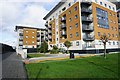
1
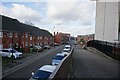
Barge House Road
Taken from the Capital Ring walk.
Image: © Ian S
Taken: 28 Jan 2020
0.01 miles
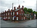
2
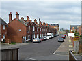
Terrace on Barge House Road, North Woolwich
Image: © Robin Webster
Taken: 5 Mar 2011
0.01 miles
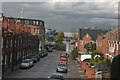
6
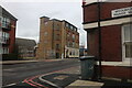
Albert Road at the junction of Woolwich Manor Way
Image: © David Howard
Taken: 13 Mar 2022
0.04 miles
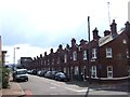
7
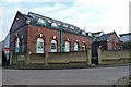
Former sewage pumping station, North Woolwich
It appears to be residential now.
Image: © Robin Webster
Taken: 5 Mar 2011
0.05 miles
8
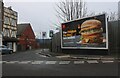
McDonald's advert on Albert Road, North Woolwich
Looking into Woodman Street
Image: © David Howard
Taken: 13 Mar 2022
0.05 miles
9
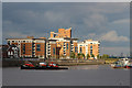
Apartment blocks at Fishguard Way
Looking from the Woolwich Ferry.
Image: © Oast House Archive
Taken: 14 Oct 2012
0.05 miles
10
Bargehouse Road, E16
Also showing the rear of houses on Woolwich Manor Way.
Image: © Danny P Robinson
Taken: 28 May 2007
0.06 miles