IMAGES TAKEN NEAR TO
Lock Side Way, LONDON, E16 2HA
Introduction
This page details the photographs taken nearby to Lock Side Way, E16 2HA by members of the Geograph project.
The Geograph project started in 2005 with the aim of publishing, organising and preserving representative images for every square kilometre of Great Britain, Ireland and the Isle of Man.

There are currently over 7.5m images from over14,400 individuals and you can help contribute to the project by visiting https://www.geograph.org.uk
Image Map
Images are licensed for reuse under creativecommons.org/licenses/by-sa/2.0
Notes
- Clicking on the map will re-center to the selected point.
- The higher the marker number, the further away the image location is from the centre of the postcode.
Image Listing (132 Images Found)
Images are licensed for reuse under creativecommons.org/licenses/by-sa/2.0
Image
Details
Distance


3
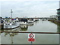
Gallions Point Marina
Looking from the top gate of the entrance lock, built in a corner of the original ship lock here. The near boats are in the rest of the old lock. The old lock was 550' x 80' (PLA 1929 map). the new lock can take boats up to only 22 m (73') long.
Image: © Robin Webster
Taken: 5 Mar 2011
0.03 miles

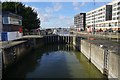
5

Albert Basin
Beyond is the River Thames, accessed via a lock to the right.
Image: © Oast House Archive
Taken: 2 Dec 2012
0.03 miles
6

Beckton : Royal Albert Wharf : housing
Housing development at Royal Albert Wharf; architects Maccreanor Lavington
Image: © Jim Osley
Taken: 23 Jul 2020
0.05 miles
7
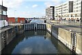
Modern lock, Royal Albert Dock
This modern lock is very much smaller than the original ship lock, within the footprint of which it has been constructed.
Image: © David Martin
Taken: 17 Dec 2023
0.05 miles
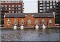
9
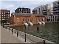
Beckton : Royal Docks Pumping Station
Erected by the Port of London Authority in 1912. Extensively described at this https://openhouselondon.open-city.org.uk/listings/1416
Image: © Jim Osley
Taken: 23 Jul 2020
0.06 miles
10
Beckton : Royal Docks Pumping Station
Erected by the Port of London Authority in 1912. Extensively described at this https://openhouselondon.open-city.org.uk/listings/1416
Image: © Jim Osley
Taken: 23 Jul 2020
0.06 miles