IMAGES TAKEN NEAR TO
Newland Street, LONDON, E16 2DU
Introduction
This page details the photographs taken nearby to Newland Street, E16 2DU by members of the Geograph project.
The Geograph project started in 2005 with the aim of publishing, organising and preserving representative images for every square kilometre of Great Britain, Ireland and the Isle of Man.

There are currently over 7.5m images from over14,400 individuals and you can help contribute to the project by visiting https://www.geograph.org.uk
Image Map
Images are licensed for reuse under creativecommons.org/licenses/by-sa/2.0
Notes
- Clicking on the map will re-center to the selected point.
- The higher the marker number, the further away the image location is from the centre of the postcode.
Image Listing (182 Images Found)
Images are licensed for reuse under creativecommons.org/licenses/by-sa/2.0
Image
Details
Distance
1

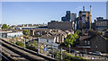
Leonard Street
Viewed from London City Airport, with the Tate & Lyle sugar refinery in the background.
Image: © Thomas Nugent
Taken: 6 Feb 2012
0.02 miles
2
Tate & Lyle factory, London
The Tate & Lyle factory at Silvertown in east London as seen from London City Airport DLR station.
Image: © Rossographer
Taken: 14 May 2019
0.03 miles
3

Leonard Street
With the Tate & Lyle sugar refinery in the background.
Image: © Thomas Nugent
Taken: 6 Feb 2012
0.04 miles
4

London City Airport
This is the airport's terminal building on Hartmann Road. The airport was constructed between 1986 and 1987, with the first commercial services commencing operations in October of that year. In 2006 more than 2.3 million passengers used the airport. The airport's website is here http://www.londoncityairport.com/
The elevated concrete viaduct carries the Docklands Light Railway on to its current terminus, King George V station, although the extension under the River Thames to Woolwich Arsenal is currently under construction.
Image: © Nigel Cox
Taken: 10 Apr 2008
0.04 miles
5

London City Airport
The eastern part of the terminal building, undergoing an expansion, from the DLR. On the left, across the Royal Albert Dock, are buildings at the University of East London.
Image: © Derek Harper
Taken: 4 Jan 2019
0.05 miles

7

Saville Road
With the Tate & Lyle sugar refinery in the background.
Image: © Thomas Nugent
Taken: 6 Feb 2012
0.05 miles
8

Covered walkway at London City Airport
Image: © Alpin Stewart
Taken: 11 Dec 2014
0.06 miles
9
Towards Woolwich Arsenal from London City Airport, DLR 2008
View from an eastbound train, at that time going only as far as King George V, the full line from Canning Town under the Thames to Woolwich being completed in 1/09.
Image: © Ben Brooksbank
Taken: 5 Aug 2008
0.06 miles
10

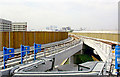
Docklands Light Railway at London City Airport
A Docklands Light Railway train approaching London City Airport station.
Image: © Malc McDonald
Taken: 3 Sep 2013
0.06 miles