IMAGES TAKEN NEAR TO
Drew Road, LONDON, E16 2DG
Introduction
This page details the photographs taken nearby to Drew Road, E16 2DG by members of the Geograph project.
The Geograph project started in 2005 with the aim of publishing, organising and preserving representative images for every square kilometre of Great Britain, Ireland and the Isle of Man.

There are currently over 7.5m images from over14,400 individuals and you can help contribute to the project by visiting https://www.geograph.org.uk
Image Map
Images are licensed for reuse under creativecommons.org/licenses/by-sa/2.0
Notes
- Clicking on the map will re-center to the selected point.
- The higher the marker number, the further away the image location is from the centre of the postcode.
Image Listing (199 Images Found)
Images are licensed for reuse under creativecommons.org/licenses/by-sa/2.0
Image
Details
Distance
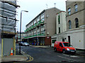
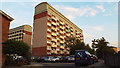
3

Flats on Drew Road
Viewed from Connaught Road.
Image: © Thomas Nugent
Taken: 6 Feb 2012
0.05 miles
4
Docklands Railway Wall in Silvertown
The decorated wall runs along Connaught Road and Albert Road parallel to the railway line.
Image: © David Howard
Taken: 13 Mar 2022
0.05 miles
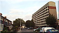
5
Flats at Silvertown
Blocks of flats at Silvertown, in London's docklands.
Image: © Malc McDonald
Taken: 3 Sep 2013
0.06 miles
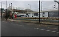
6
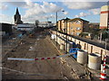
Crossrail works at Silvertown
Looking north / west from the site of Silvertown station on the North Woolwich branch. The former railway line has been cleared as part of the Crossrail construction project.
Image: © Gareth James
Taken: 11 Nov 2012
0.06 miles
7

Former Silvertown Station
Silvertown was on the North London Line until the section from Stratford to North Woolwich was closed in December 2006. It is now being redeveloped under the Crossrail scheme ( http://www.crossrail.co.uk/ ). The Tate & Lyle sugar refinery dominates the background.
See the station shortly after closure here Image
Image: © Thomas Nugent
Taken: 6 Feb 2012
0.06 miles
8

Former Silvertown Station
Silvertown was on the North London Line until the section from Stratford to North Woolwich was closed in December 2006. It is now being redeveloped under the Crossrail scheme ( http://www.crossrail.co.uk/ ). The Tate & Lyle sugar refinery dominates the background.
See the station shortly after closure here Image
Image: © Thomas Nugent
Taken: 6 Feb 2012
0.06 miles
9
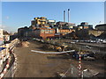
Crossrail works at Silvertown
The site of Silvertown station on the North Woolwich branch has been cleared as part of the Crossrail construction project. Behind is the Tate & Lyle factory.
Image: © Gareth James
Taken: 11 Nov 2012
0.06 miles
10
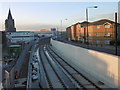
Crossrail under construction at Silvertown
This view is from the footbridge at the former Silvertown station and looks towards the tunnel under the cut between the Victoria Dock and the Royal Albert Dock. The tunnel, which was disused after the North London Line between Stratford and North Woolwich was closed on 9th December 2006, has now been refurbished and will take Crossrail trains between Woolwich and Custom House stations. The church on the left is St Mark's, Silvertown - see http://www.geograph.org.uk/photo/4799508
Silvertown station was opened by the Great Eastern Railway on 19th June 1863. When the Royal Albert Dock was built in 1880, the railway was diverted through a tunnel under the cut between the Victoria Dock and the Royal Albert Dock. Silvertown station was rebuilt in 1885 and 1979, but the station which was then on the North London Line, was closed with the rest of the line between Stratford and North Woolwich on 9th December 2006. The station was demolished in 2012. For a much fuller history and a chronological series of photographs of the station of and from this same footbridge see http://www.disused-stations.org.uk/s/silvertown/
Image: © Marathon
Taken: 20 Jan 2016
0.06 miles