IMAGES TAKEN NEAR TO
Fort Street, LONDON, E16 2BD
Introduction
This page details the photographs taken nearby to Fort Street, E16 2BD by members of the Geograph project.
The Geograph project started in 2005 with the aim of publishing, organising and preserving representative images for every square kilometre of Great Britain, Ireland and the Isle of Man.

There are currently over 7.5m images from over14,400 individuals and you can help contribute to the project by visiting https://www.geograph.org.uk
Image Map
Images are licensed for reuse under creativecommons.org/licenses/by-sa/2.0
Notes
- Clicking on the map will re-center to the selected point.
- The higher the marker number, the further away the image location is from the centre of the postcode.
Image Listing (320 Images Found)
Images are licensed for reuse under creativecommons.org/licenses/by-sa/2.0
Image
Details
Distance
3
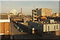
Fort Street, E16
A view from the DLR with the old Silvertown Fire Station. Behind it on the right are the Spillers Millennium Mills http://www.geograph.org.uk/search.php?i=90357594 . The chimney left of centre is shown in Image; to its left is Eastern Quay (see also Image]).
Image: © Derek Harper
Taken: 4 Jan 2019
0.04 miles
4
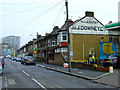
Boxley Street, E16
Seen from the DLR. The "J & J Downey" is a ghost sign. In the background is the distinctive shape of the Eastern Quay apartments (Gardner Stewart Architects, 2002-3).
Image: © Derek Harper
Taken: 4 Jan 2019
0.04 miles
5

Mill Road
The chimney stands alone on a roundabout, near the Millennium Mills building Image
Image: © Thomas Nugent
Taken: 6 Feb 2012
0.05 miles
6
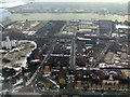
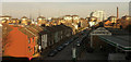
Silvertown from the air
On final approach to London City Airport from the west.
Image: © Thomas Nugent
Taken: 6 Feb 2012
0.05 miles
7
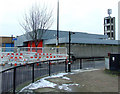
Silvertown Fire Station
Obscured by roadworks barriers, on North Woolwich Road at Mill Road.
Image: © Thomas Nugent
Taken: 6 Feb 2012
0.06 miles
8
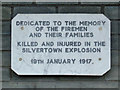
Silvertown explosion memorial plaque
On the exterior wall of Silvertown fire station Image Here is a http://en.wikipedia.org/wiki/Silvertown_explosion to the wikipedia article about the explosion.
Image: © Thomas Nugent
Taken: 6 Feb 2012
0.06 miles
9
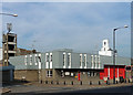
Fire station, North Woolwich Road
Silvertown station, in the 1960s house style (c.f. Image]).
A previous station was destroyed by an explosion at a nearby munitions factory in 1917.
Image: © Stephen Richards
Taken: 1 Oct 2011
0.06 miles
10
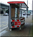
Bus shelter on North Woolwich Road
Closed for the time being.
Image: © Thomas Nugent
Taken: 6 Feb 2012
0.07 miles