IMAGES TAKEN NEAR TO
Scoulding Road, LONDON, E16 1NT
Introduction
This page details the photographs taken nearby to Scoulding Road, E16 1NT by members of the Geograph project.
The Geograph project started in 2005 with the aim of publishing, organising and preserving representative images for every square kilometre of Great Britain, Ireland and the Isle of Man.

There are currently over 7.5m images from over14,400 individuals and you can help contribute to the project by visiting https://www.geograph.org.uk
Image Map
Images are licensed for reuse under creativecommons.org/licenses/by-sa/2.0
Notes
- Clicking on the map will re-center to the selected point.
- The higher the marker number, the further away the image location is from the centre of the postcode.
Image Listing (58 Images Found)
Images are licensed for reuse under creativecommons.org/licenses/by-sa/2.0
Image
Details
Distance
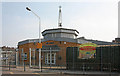
1
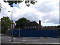
Pitts Head, Public House, Canning Town
Closed and blocked off public house on the junction of Fords Park Road and Vincent Street (in front).
Image: © David Anstiss
Taken: 26 Aug 2012
0.03 miles
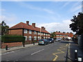
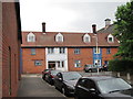
2
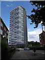
Ferrier Point, Canning Town
Large block of housing on Forty Acre Lane.
Image: © David Anstiss
Taken: 26 Aug 2012
0.09 miles
7

St Luke, Ruscoe Road - Stained glass window
Image: © John Salmon
Taken: 8 May 2011
0.15 miles
8
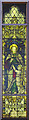
St Luke, Ruscoe Road - Stained glass window
Image: © John Salmon
Taken: 8 May 2011
0.15 miles
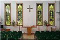
10
Christian centre, Vincent Street
Image: © Oast House Archive
Taken: 19 Jun 2014
0.15 miles