IMAGES TAKEN NEAR TO
Robertson Road, LONDON, E16 1FT
Introduction
This page details the photographs taken nearby to Robertson Road, E16 1FT by members of the Geograph project.
The Geograph project started in 2005 with the aim of publishing, organising and preserving representative images for every square kilometre of Great Britain, Ireland and the Isle of Man.

There are currently over 7.5m images from over14,400 individuals and you can help contribute to the project by visiting https://www.geograph.org.uk
Image Map
Images are licensed for reuse under creativecommons.org/licenses/by-sa/2.0
Notes
- Clicking on the map will re-center to the selected point.
- The higher the marker number, the further away the image location is from the centre of the postcode.
Image Listing (35 Images Found)
Images are licensed for reuse under creativecommons.org/licenses/by-sa/2.0
Image
Details
Distance
3
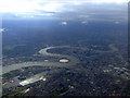
Greenwich from the air
Looking over Greenwich to the Isle of Dogs. Viewed from a Heathrow bound flight from Glasgow.
Image: © Thomas Nugent
Taken: 29 Aug 2011
0.12 miles
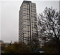
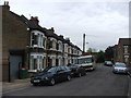
6
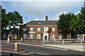
YMCA George Williams College
On Freemasons Road, E16.
Image: © Robin Webster
Taken: 11 Jun 2011
0.15 miles
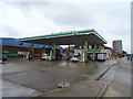
8
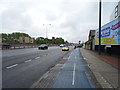
London Cycle Superhighway 3 (CS3)
Heading east beside the A13.
Image: © JThomas
Taken: 11 May 2019
0.16 miles
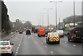
10
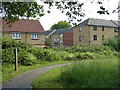
Path in Ashburton Wood
A small public park.
Image: © Robin Webster
Taken: 11 Jun 2011
0.16 miles