IMAGES TAKEN NEAR TO
Collingwood Street, LONDON, E1 5RF
Introduction
This page details the photographs taken nearby to Collingwood Street, E1 5RF by members of the Geograph project.
The Geograph project started in 2005 with the aim of publishing, organising and preserving representative images for every square kilometre of Great Britain, Ireland and the Isle of Man.

There are currently over 7.5m images from over14,400 individuals and you can help contribute to the project by visiting https://www.geograph.org.uk
Image Map (Loading...)


Getting Data...Please wait
Leaflet Map data © OpenStreetMap
Images are licensed for reuse under creativecommons.org/licenses/by-sa/2.0
Notes
- Clicking on the map will re-center to the selected point.
- The higher the marker number, the further away the image location is from the centre of the postcode.
Image Listing (179 Images Found)
Images are licensed for reuse under creativecommons.org/licenses/by-sa/2.0
Image
Details
Distance
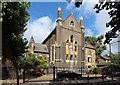
3
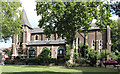
St Bartholomew, Bethnal Green
Now residential
Image: © John Salmon
Taken: 9 Aug 2014
0.05 miles
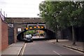
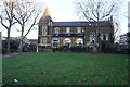
4
Steeple Court on Coventry Road, Bethnal Green, London
Formerly St Bartholomew's Church.
Image: © Ian S
Taken: 26 Jan 2020
0.05 miles
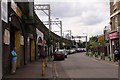
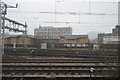
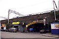
6

Adjacent track near Bethnal Green
Taken between Bethnal Green and Mile End stations. Looking towards Three Colts Lane.
Image: © Clint Mann
Taken: 3 May 2016
0.05 miles
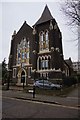
7
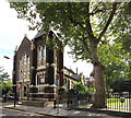
St Bartholomew, Bethnal Green
Now residential
Image: © John Salmon
Taken: 9 Aug 2014
0.06 miles
9
Turf Zone "StBartholmew"
St Bartholomew's Gardens, Bethnal Green, London.
Image: © Ian S
Taken: 26 Dec 2022
0.06 miles
10
St Bartholomew, Bethnal Green
Now residential
Image: © John Salmon
Taken: 9 Aug 2014
0.06 miles