IMAGES TAKEN NEAR TO
Durward Street, LONDON, E1 5BB
Introduction
This page details the photographs taken nearby to Durward Street, E1 5BB by members of the Geograph project.
The Geograph project started in 2005 with the aim of publishing, organising and preserving representative images for every square kilometre of Great Britain, Ireland and the Isle of Man.

There are currently over 7.5m images from over14,400 individuals and you can help contribute to the project by visiting https://www.geograph.org.uk
Image Map
Images are licensed for reuse under creativecommons.org/licenses/by-sa/2.0
Notes
- Clicking on the map will re-center to the selected point.
- The higher the marker number, the further away the image location is from the centre of the postcode.
Image Listing (344 Images Found)
Images are licensed for reuse under creativecommons.org/licenses/by-sa/2.0
Image
Details
Distance
1
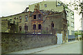
Essex Wharf, Durward Street, 1988
The viewpoint is just about where the body of Jack the Ripper victim Mary Ann Nichols was found 100 years before the photograph. The street was then called Buck's Row. The "Wharf" name did not indicate a nearby navigation, but possibly the nearby railway yards.
Image: © Robin Webster
Taken: Unknown
0.02 miles
2
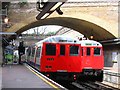
East London Line trains at Whitechapel station
This photo was taken only a couple of months before the East London Line closed for its metamorphosis into the London Overground. See also Image Underground trains nos. 5065 and 5109.
Image: © Stephen Craven
Taken: 30 Apr 2006
0.03 miles
3
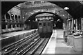
Whitechapel Station ? 1970
At this time service on the East London Line was still provided by Q-stock with its distinctive clerestory roofs, shortly to be replaced by the A60 stock seen in Dr Clifton's view from 1979 https://www.geograph.org.uk/photo/560008
Image: © Alan Murray-Rust
Taken: 24 Jul 1970
0.03 miles
4

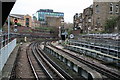
Railway line to the east of Whitechapel tube station
Image: © Oxyman
Taken: 20 Mar 2009
0.03 miles
5
Looking East along the District Line from Whitechapel
This photograph shows the sharp curve and steep gradient faced by westbound trains about to enter Whitechapel station.
Image: © Dr Neil Clifton
Taken: 28 Nov 2007
0.04 miles
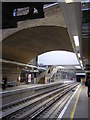
6
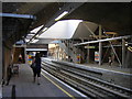
Whitechapel Station, East London Line
Standing on the southbound platform of the Overground (formerly the East London Line), looking up and westwards between the two westbound tracks of the District / Hammersmith & City Lines. Crossing high above, the pedestrian footbridge that leads passengers from those upper lines to the ticket hall, which is to the left and off the edge of the picture.
Image: © Christopher Hilton
Taken: 14 Jul 2011
0.04 miles
7
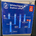
Diagram of the lifts, Whitechapel station
This prompts as many questions as it answers. If you're already familiar with the station it could make sense. Note the Elizabeth Line (Crossrail) at the deepest level. The section between Abbey Wood and Paddington had not long been open (mid-May 2022).
Image: © Robin Stott
Taken: 13 May 2022
0.04 miles
8
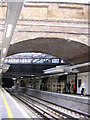
Whitechapel Station, East London Line
The northbound platform of the East London Line, very recently reopened as part of the London Overground network.
Image: © Christopher Hilton
Taken: 4 Jun 2010
0.04 miles
9
Whitechapel Station, East London Line
Standing on the southbound platform of the East London Line, very recently reopened as part of the London Overground network.
Image: © Christopher Hilton
Taken: 26 May 2010
0.04 miles
10
Whitechapel Station, East London Line
Southbound platform of the East London Line, very recently reopened as part of the London Overground network.
Image: © Christopher Hilton
Taken: 26 May 2010
0.04 miles