IMAGES TAKEN NEAR TO
West Ham Lane, LONDON, E15 4SF
Introduction
This page details the photographs taken nearby to West Ham Lane, E15 4SF by members of the Geograph project.
The Geograph project started in 2005 with the aim of publishing, organising and preserving representative images for every square kilometre of Great Britain, Ireland and the Isle of Man.

There are currently over 7.5m images from over14,400 individuals and you can help contribute to the project by visiting https://www.geograph.org.uk
Image Map (Loading...)


Getting Data...Please wait
Leaflet Map data © OpenStreetMap
Images are licensed for reuse under creativecommons.org/licenses/by-sa/2.0
Notes
- Clicking on the map will re-center to the selected point.
- The higher the marker number, the further away the image location is from the centre of the postcode.
Image Listing (290 Images Found)
Images are licensed for reuse under creativecommons.org/licenses/by-sa/2.0
Image
Details
Distance
1
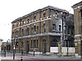
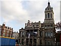
West Ham Court House, Stratford
Grade II listed building on West Ham Lane, near the former Town Hall.
See http://www.britishlistedbuildings.co.uk/en-204978-west-ham-court-house-greater-london-auth for more details about the building.
Image: © David Anstiss
Taken: 26 Aug 2012
0.02 miles
2
West Ham Courthouse
A grade II listed building of 1884. Beyond is the former West Ham town hall, grade II listed, 1867-8 and 1886.
Image: © Robin Webster
Taken: 29 Jan 2011
0.02 miles
3
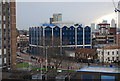
New development, Stratford
A conference & leisure centre.
Image: © N Chadwick
Taken: 20 Jan 2009
0.03 miles
4
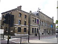
Stratford Education Offices
Grade II listed building that was once Stratford Town Hall.
See http://www.britishlistedbuildings.co.uk/en-204928-education-offices-greater-london-authori for more details about the building.
Image: © David Anstiss
Taken: 26 Aug 2012
0.04 miles
5
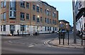
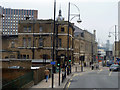
Victoria Street at the junction of West Ham Lane
Image: © David Howard
Taken: 22 Jan 2023
0.04 miles
6
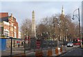
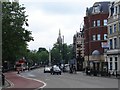
Stratford Broadway
A sudden burst of sunshine and you take a photo, wherever you are. I'm waiting for a D8 bus beside some very unprepossessing roadworks barriers at Stratford Broadway. Left of centre is the Gurney Memorial obelisk (1861 http://www.britishlistedbuildings.co.uk/en-204924-gurney-memorial-drinking-fountain-stratf ). Rising above the trees in the middle of the Broadway is the spire of John's Church. Note the enigmatic red notice in the central foreground, reminiscent of Magritte: "This is not a pedestrian crossing". Well, I'm short-sighted but I'd spotted that. Is that my bus? No, it's a 257.
Image: © Derek Harper
Taken: 2 Feb 2011
0.04 miles
7
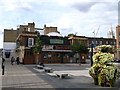
Queen's Head, Stratford
Former Public house on the island between West Ham Lane (on the left) and Tramway Avenue (on the right).
Now a cafe and restaurant.
Image: © David Anstiss
Taken: 26 Aug 2012
0.04 miles
8
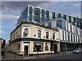
The Princess of Wales, Public house, Stratford
Public house on the junction of Victoria Street (on the left) and West Hame lane.
A block of offices is behind.
Image: © David Anstiss
Taken: 26 Aug 2012
0.04 miles
9
Stratford Old Town Hall, The Broadway E15
At the junction with West Ham Lane
Image: © Robin Sones
Taken: 2 Nov 2011
0.05 miles
10
Stratford Broadway
View from the traffic island.
Image: © Ian Paterson
Taken: 12 Jun 2008
0.05 miles