IMAGES TAKEN NEAR TO
Keogh Road, LONDON, E15 4NR
Introduction
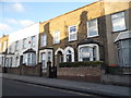
This page details the photographs taken nearby to Keogh Road, E15 4NR by members of the Geograph project.
The Geograph project started in 2005 with the aim of publishing, organising and preserving representative images for every square kilometre of Great Britain, Ireland and the Isle of Man.

There are currently over 7.5m images from over14,400 individuals and you can help contribute to the project by visiting https://www.geograph.org.uk
Image Map
Images are licensed for reuse under creativecommons.org/licenses/by-sa/2.0
Notes
- Clicking on the map will re-center to the selected point.
- The higher the marker number, the further away the image location is from the centre of the postcode.
Image Listing (84 Images Found)
Images are licensed for reuse under creativecommons.org/licenses/by-sa/2.0
Image
Details
Distance
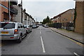
2
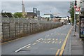
Forest Lane, Maryland
Seen here from the junction with Maryland Park, Forest Lane runs parallel with the railway - the tops of the electrification masts can be seen.
Image: © Stephen McKay
Taken: 1 Oct 2015
0.04 miles
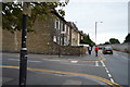
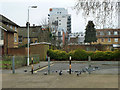
3
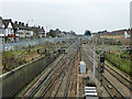
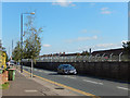
Great Eastern main line, Maryland
Looking east towards Forest Gate from the Water Lane bridge.
Image: © Robin Webster
Taken: 29 Jan 2011
0.04 miles
5
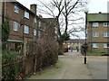
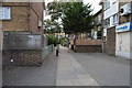
Path from Thorogood Gardens to Forest Lane, E15
On a housing estate.
Image: © Robin Webster
Taken: 29 Jan 2011
0.05 miles
6
End of Thorogood Gardens
A path continues through to Forest Lane.
Image: © Robin Webster
Taken: 29 Jan 2011
0.07 miles