IMAGES TAKEN NEAR TO
Tennyson Road, LONDON, E15 4DJ
Introduction
This page details the photographs taken nearby to Tennyson Road, E15 4DJ by members of the Geograph project.
The Geograph project started in 2005 with the aim of publishing, organising and preserving representative images for every square kilometre of Great Britain, Ireland and the Isle of Man.

There are currently over 7.5m images from over14,400 individuals and you can help contribute to the project by visiting https://www.geograph.org.uk
Image Map
Images are licensed for reuse under creativecommons.org/licenses/by-sa/2.0
Notes
- Clicking on the map will re-center to the selected point.
- The higher the marker number, the further away the image location is from the centre of the postcode.
Image Listing (88 Images Found)
Images are licensed for reuse under creativecommons.org/licenses/by-sa/2.0
Image
Details
Distance
1
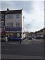
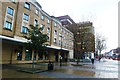
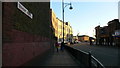
Stratford Dental Practice, Romford Road E15
At the junction with Tennyson Road
Image: © Robin Sones
Taken: 2 Nov 2011
0.08 miles
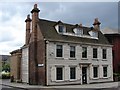
3
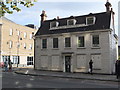
The Old Dispensary, Romford Road E15
At the junction with Mantle Way
Image: © Robin Sones
Taken: 2 Nov 2011
0.09 miles
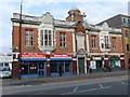
4
The Old Dispensary
At the corner of Mantle Way and Romford Road lies this timber-clad Listed Building, built c1700.
Image: © Ian Paterson
Taken: 12 Jun 2008
0.10 miles
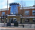
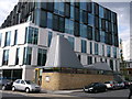
5
Ibis Hotel at junction on Romford Road
Romford Road is the A118
Image: © Clint Mann
Taken: 8 Dec 2015
0.13 miles
6
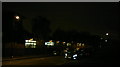
View of Deanery Road Children's Nursery from Water Lane
Somewhere on the corner of Deanery Road and Water Lane stood a German prisoner of war camp 100 years ago. I know this as I am currently volunteering for an oral history and community research charity in my local area on a project about two prisoner of war camps in Stratford - the other was on Carpenter's Road. Apologies that the shot was taken at night - I am coming back here to work again soon and so will get a daytime shot for better clarity. Looking west.
Image: © Robert Lamb
Taken: 10 Dec 2013
0.15 miles
8
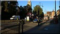
Stratford Broadway and St John's Church
Stratford Broadway and St John's Church on a sunny but cold afternoon in November 2006.
Image: © P M Simpson
Taken: 2 Nov 2006
0.16 miles
9
Stratford - Tramway Avenue
Stratford looking south down tramway avenue. Named this because the North Metropolitan Tramways had their horse tramway depot there in front where the new buildings are now seen.
Image: © P M Simpson
Taken: 2 Nov 2006
0.16 miles
10
Unitarian and Free Christian Church, Stratford
Modern church on West Ham Lane. Beside a modern office block.
Image: © David Anstiss
Taken: 26 Aug 2012
0.17 miles