IMAGES TAKEN NEAR TO
Morton Road, LONDON, E15 4AN
Introduction
This page details the photographs taken nearby to Morton Road, E15 4AN by members of the Geograph project.
The Geograph project started in 2005 with the aim of publishing, organising and preserving representative images for every square kilometre of Great Britain, Ireland and the Isle of Man.

There are currently over 7.5m images from over14,400 individuals and you can help contribute to the project by visiting https://www.geograph.org.uk
Image Map
Images are licensed for reuse under creativecommons.org/licenses/by-sa/2.0
Notes
- Clicking on the map will re-center to the selected point.
- The higher the marker number, the further away the image location is from the centre of the postcode.
Image Listing (39 Images Found)
Images are licensed for reuse under creativecommons.org/licenses/by-sa/2.0
Image
Details
Distance
1
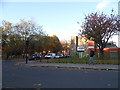
Portway at the junction of Vicarage Lane
The Islamic Education Centre is opposite
Image: © David Howard
Taken: 12 Nov 2017
0.08 miles
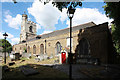
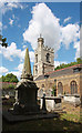
4
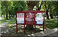
All Saints, Church Street, West Ham - Notice board
Image: © John Salmon
Taken: 10 May 2011
0.11 miles
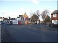
5
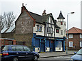
The Angel, West Ham
A rough bar for gentle people.
Image: © Robin Webster
Taken: 29 Jan 2011
0.11 miles
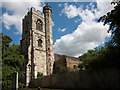
6
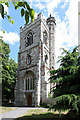
All Saints, Church Street, West Ham - Tower
Image: © John Salmon
Taken: 10 May 2011
0.11 miles