IMAGES TAKEN NEAR TO
Abbey Road, LONDON, E15 3LT
Introduction
This page details the photographs taken nearby to Abbey Road, E15 3LT by members of the Geograph project.
The Geograph project started in 2005 with the aim of publishing, organising and preserving representative images for every square kilometre of Great Britain, Ireland and the Isle of Man.

There are currently over 7.5m images from over14,400 individuals and you can help contribute to the project by visiting https://www.geograph.org.uk
Image Map (Loading...)


Getting Data...Please wait
Leaflet Map data © OpenStreetMap
Images are licensed for reuse under creativecommons.org/licenses/by-sa/2.0
Notes
- Clicking on the map will re-center to the selected point.
- The higher the marker number, the further away the image location is from the centre of the postcode.
Image Listing (57 Images Found)
Images are licensed for reuse under creativecommons.org/licenses/by-sa/2.0
Image
Details
Distance
1
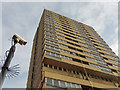
Brassett Point
This block on Abbey Road was one of a pair built in 1965 with 21 floors.
Image: © Stephen McKay
Taken: 9 Dec 2016
0.03 miles
2
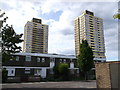
Housing near Manor Road
On the left is Brassett Point and on the right is David Lee Point. Two large housing blocks on Abbey Road.
Image: © David Anstiss
Taken: 26 Aug 2012
0.05 miles
3
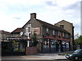
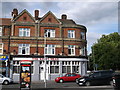
The Greyhound Public House, West Ham
Pub on the junction of Abbey Road (on the left) and West Ham Lane.
Image: © David Anstiss
Taken: 26 Aug 2012
0.08 miles
4
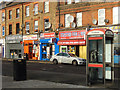
Church Street, Stratford
A line of shops on Church Street consisting of a tattoo parlour, two fast food take-aways, a food and wine general store, and a minicab office: a fairly typical selection for an inner city location.
Image: © Stephen McKay
Taken: 9 Dec 2016
0.11 miles
5
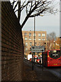
Manor Road, West Ham
A bus on route 276, towards Stoke Newington, approaches the junction with New Plaistow Road.
Image: © Stephen McKay
Taken: 9 Dec 2016
0.11 miles
6
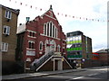
West Ham Baptist Tabernacle
Church on West Ham Lane.
Image: © David Anstiss
Taken: 26 Aug 2012
0.11 miles
7
The Kings Head, West Ham
Former public house on Church Street, was used as a guest house at one stage.
Image: © David Anstiss
Taken: 26 Aug 2012
0.11 miles
8
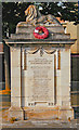
West Ham : Crockett's Leathercloth Works War Memorial
Grade II listed war memorial. https://historicengland.org.uk/listing/the-list/list-entry/1430693.
Image: © Jim Osley
Taken: 26 May 2020
0.11 miles
9
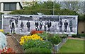
Close up of photograph in Abbey Gardens
This photograph in its context can be seen at http://www.geograph.org.uk/photo/3454165 where more information can be seen about the site. The flowers add welcome colour to the gardens.
Image: © Marathon
Taken: 8 May 2013
0.13 miles
10
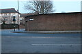
Manor Road at the junction of New Plaistow Road
The wall protects a long row of garages for the houses opposite them.
Image: © David Howard
Taken: 22 Jan 2023
0.13 miles