IMAGES TAKEN NEAR TO
Ada Gardens, LONDON, E15 3EW
Introduction
This page details the photographs taken nearby to Ada Gardens, E15 3EW by members of the Geograph project.
The Geograph project started in 2005 with the aim of publishing, organising and preserving representative images for every square kilometre of Great Britain, Ireland and the Isle of Man.

There are currently over 7.5m images from over14,400 individuals and you can help contribute to the project by visiting https://www.geograph.org.uk
Image Map
Images are licensed for reuse under creativecommons.org/licenses/by-sa/2.0
Notes
- Clicking on the map will re-center to the selected point.
- The higher the marker number, the further away the image location is from the centre of the postcode.
Image Listing (32 Images Found)
Images are licensed for reuse under creativecommons.org/licenses/by-sa/2.0
Image
Details
Distance
3
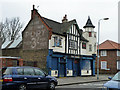
The Angel, West Ham
A rough bar for gentle people.
Image: © Robin Webster
Taken: 29 Jan 2011
0.18 miles
4
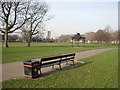
A Grade II Listed Park
West Ham Park, 77 acres, has been owned and managed by the Corporation of the City of London, whose the arms are proudly borne on the litter bins, since 1874. The park is listed as a Grade II site on the English Heritage Register of parks and gardens of specific historic interest.
Image: © John Davies
Taken: 24 Jan 2006
0.19 miles
5
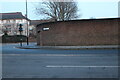
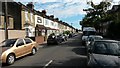
Manor Road at the junction of New Plaistow Road
The wall protects a long row of garages for the houses opposite them.
Image: © David Howard
Taken: 22 Jan 2023
0.19 miles
7
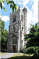
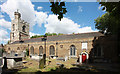
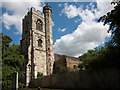
All Saints, Church Street, West Ham - Tower
Image: © John Salmon
Taken: 10 May 2011
0.21 miles
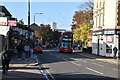
10
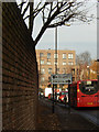
Manor Road, West Ham
A bus on route 276, towards Stoke Newington, approaches the junction with New Plaistow Road.
Image: © Stephen McKay
Taken: 9 Dec 2016
0.21 miles