IMAGES TAKEN NEAR TO
Sugar House Lane, LONDON, E15 2ZQ
Introduction
This page details the photographs taken nearby to Sugar House Lane, E15 2ZQ by members of the Geograph project.
The Geograph project started in 2005 with the aim of publishing, organising and preserving representative images for every square kilometre of Great Britain, Ireland and the Isle of Man.

There are currently over 7.5m images from over14,400 individuals and you can help contribute to the project by visiting https://www.geograph.org.uk
Image Map (Loading...)


Getting Data...Please wait
Leaflet Map data © OpenStreetMap
Images are licensed for reuse under creativecommons.org/licenses/by-sa/2.0
Notes
- Clicking on the map will re-center to the selected point.
- The higher the marker number, the further away the image location is from the centre of the postcode.
Image Listing (194 Images Found)
Images are licensed for reuse under creativecommons.org/licenses/by-sa/2.0
Image
Details
Distance
1
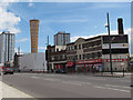
Stratford High Street
Some older buildings in the foreground, including an engineering works, and behind them a new "olympic torch" structure - see Image for a full-height view.
Image: © Stephen Craven
Taken: 17 Jun 2012
0.08 miles
2
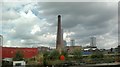
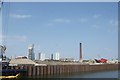
View of an old factory chimney and flats on Stratford High Street from the Lea Navigation
Looking north-northeast.
Image: © Robert Lamb
Taken: 25 Jul 2013
0.09 miles
3
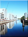
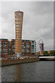
Three Mills Wall River, Stratford, London
A view from a spot immediately north of the Three Mills Residential Moorings facility. The cylindrical tower ahead (a.k.a. the Strand Tower East) - a hollow, latticed timber sculpture - is situated in the historic Dane's Yard area of Sugar House Island. Beyond it is Groves Bridge that carries the A118 through Stratford.
Image: © David Hallam-Jones
Taken: 21 Sep 2019
0.09 miles
5
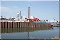
View of derelict industrial land from the River Lea Navigation
Looking north-northeast.
Image: © Robert Lamb
Taken: 5 Jun 2016
0.10 miles
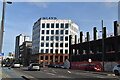
6
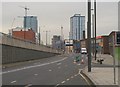
A11 slip road
Mostly leading towards the camera from Stratford High Street to the Bow Bridge roundabout. But note the far lane going in the other direction, as far as a right turn into the Sugar House area. In the background, high rises along Stratford High Street, with more going up fast. Taken from a bus stop pull-in.
Image: © Derek Harper
Taken: 1 Feb 2011
0.10 miles
7
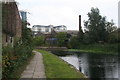
The Lee Navigation
Looking north, just north of Three Mills Bridge.
Image: © Dr Neil Clifton
Taken: 18 Sep 2008
0.10 miles
8
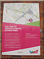
Poster for the Olympic Park
Giving directions for pedestrians on the Greenway diversion.
Image: © Stephen Craven
Taken: 15 Jun 2014
0.10 miles
9
View of derelict industrial land from the River Lea Navigation #2
Looking north-northeast.
Image: © Robert Lamb
Taken: 5 Jun 2016
0.10 miles
10
Olympic torch structure
This large-scale representation of the Olympic torch stands at the rear of industrial premises at the top of Sugar House Lane near its junction with High Street (whose bridge across Three Mills Wall River can be seen on the right).
Image: © David Kemp
Taken: 6 Jun 2012
0.11 miles