IMAGES TAKEN NEAR TO
Streimer Road, LONDON, E15 2RL
Introduction
This page details the photographs taken nearby to Streimer Road, E15 2RL by members of the Geograph project.
The Geograph project started in 2005 with the aim of publishing, organising and preserving representative images for every square kilometre of Great Britain, Ireland and the Isle of Man.

There are currently over 7.5m images from over14,400 individuals and you can help contribute to the project by visiting https://www.geograph.org.uk
Image Map
Images are licensed for reuse under creativecommons.org/licenses/by-sa/2.0
Notes
- Clicking on the map will re-center to the selected point.
- The higher the marker number, the further away the image location is from the centre of the postcode.
Image Listing (156 Images Found)
Images are licensed for reuse under creativecommons.org/licenses/by-sa/2.0
Image
Details
Distance
1
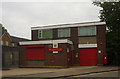
Stratford Delivery Office, Abbey Lane, Stratford, E15
Image: © Jim Osley
Taken: 10 Jun 2010
0.05 miles
2
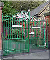
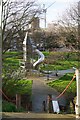
Gates and lodge, Abbey Lane
At the entrance to the pumping station (Image]), and no doubt contemporaneous. The gates have decorative cresting. Grade II listed.
Image: © Stephen Richards
Taken: 17 Sep 2017
0.08 miles
3
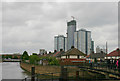
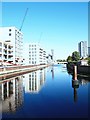
Tower blocks in Stratford
Taken from the confluence of Three Mills Wall River (left) and Prescott Channel (right). The houses are in Bisson Road. The middle of the three blocks is the Athena Building, a commercial and residential block on the corner of Warton Road and High Street whose construction is near completion. The two either side of it are Aubrey Moore Point (left) and Albert Bigg Point (right) both dating from 1968.
Image: © David Kemp
Taken: 6 Jun 2012
0.09 miles
4
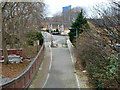
Abbey Lane, E15
This part is blocked off as a through vehicle route.
Image: © Robin Webster
Taken: 11 Dec 2010
0.10 miles
7

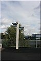
Warning sign on The Greenway
You don't see these kind of signs in Yorkshire.
Image: © Ian S
Taken: 28 Jan 2020
0.11 miles
8
Three Mills Wall River, Stratford, London
A view from a spot immediately north of the Three Mills Residential Moorings facility. The cylindrical tower ahead (a.k.a. the Strand Tower East) - a hollow, latticed timber sculpture - is situated in the historic Dane's Yard area of Sugar House Island. Beyond it is Groves Bridge that carries the A118 through Stratford.
Image: © David Hallam-Jones
Taken: 21 Sep 2019
0.12 miles
9
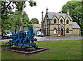
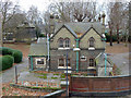
Offices, Abbey Lane
Built as the (unenviably-sited) residence of the superintendent of the pumping station (Image]), c1865, perhaps also to the design of Charles Driver as it has similar Gothic and Byzantine motifs. Grade II listed.
In front is a bit of now-redundant pumping station kit.
Image: © Stephen Richards
Taken: 17 Sep 2017
0.12 miles
10
Ancillary building, Abbey Mills pumping station
Near the Willis Road boundary of this wonderful site, with the grade II listed base of one of the two demolished chimneys to the left. This building, offices formerly the superintendent's house, is also grade II listed.
Image: © Robin Webster
Taken: 11 Dec 2010
0.12 miles