IMAGES TAKEN NEAR TO
Doran Walk, LONDON, E15 2JJ
Introduction
This page details the photographs taken nearby to Doran Walk, E15 2JJ by members of the Geograph project.
The Geograph project started in 2005 with the aim of publishing, organising and preserving representative images for every square kilometre of Great Britain, Ireland and the Isle of Man.

There are currently over 7.5m images from over14,400 individuals and you can help contribute to the project by visiting https://www.geograph.org.uk
Image Map
Images are licensed for reuse under creativecommons.org/licenses/by-sa/2.0
Notes
- Clicking on the map will re-center to the selected point.
- The higher the marker number, the further away the image location is from the centre of the postcode.
Image Listing (355 Images Found)
Images are licensed for reuse under creativecommons.org/licenses/by-sa/2.0
Image
Details
Distance
1
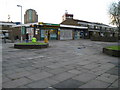
Stratford: Doran Walk, E15
The Londis convenience store and the Metropolitan Police's Safer Neighbourhoods Stratford station can be seen.
Londis was established in 1959 by a group of independent retail grocers belonging to the LONdon DIStrict Council of the National Council of Grocers (hence the name Londis). They had the aim of establishing a fully operational delivered wholesale company owned jointly by the retailers it served. It now has over 2,200 members, all of them independent store owners.
The Police Station is one of about twenty small community policing stations in the London Borough of Newham.
Image: © Nigel Cox
Taken: 1 May 2008
0.03 miles
2
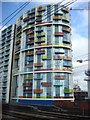
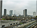
New Flats
New Flats in Stratford, part of the Olympic regeneration
Image: © Oxyman
Taken: 20 Mar 2007
0.05 miles
4
View of the Aquatics Centre from Carpenter's Road
Looking north-northwest. The road is currently closed as a new roundabout joining it with the new Westfield Way (on a concrete flyover behind the blue railway bridge) is being constructed. The roundabout joining nearby Warton Road to Westfield Way is now nearly complete, so it shouldn't be long before this roundabout is complete either.
Image: © Robert Lamb
Taken: 8 Jan 2012
0.05 miles
5
View south from DLR platform, Stratford
Image: © Robin Webster
Taken: 29 Jan 2011
0.05 miles
6
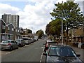
Wilmer Lea Close, Stratford
The Olympic stadium under construction can just be seen in the background.
Image: © Steve Fareham
Taken: 11 Aug 2009
0.06 miles
7

View of towerblocks on Stratford High Street and Warton Road from Queen Elizabeth Olympic Park #2
Looking south-southeast.
Image: © Robert Lamb
Taken: 22 Jun 2014
0.07 miles
8
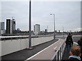
Buildings and railway lines in Stratford, viewed from Westfield Way #2
Looking south-southwest.
Image: © Robert Lamb
Taken: 8 Jan 2012
0.07 miles
9
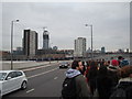
View of towerblocks in Stratford, viewed from Westfield Way
Looking south-southwest.
Image: © Robert Lamb
Taken: 8 Jan 2012
0.07 miles
10

View of towerblocks on Stratford High Street and Warton Road from Queen Elizabeth Olympic Park
Looking south-southwest.
Image: © Robert Lamb
Taken: 22 Jun 2014
0.08 miles