IMAGES TAKEN NEAR TO
High Road Leyton, LONDON, E15 2BP
Introduction
This page details the photographs taken nearby to High Road Leyton, E15 2BP by members of the Geograph project.
The Geograph project started in 2005 with the aim of publishing, organising and preserving representative images for every square kilometre of Great Britain, Ireland and the Isle of Man.

There are currently over 7.5m images from over14,400 individuals and you can help contribute to the project by visiting https://www.geograph.org.uk
Image Map (Loading...)


Getting Data...Please wait
Leaflet Map data © OpenStreetMap
Images are licensed for reuse under creativecommons.org/licenses/by-sa/2.0
Notes
- Clicking on the map will re-center to the selected point.
- The higher the marker number, the further away the image location is from the centre of the postcode.
Image Listing (51 Images Found)
Images are licensed for reuse under creativecommons.org/licenses/by-sa/2.0
Image
Details
Distance
5
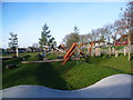
Drapers Field - an Olympic legacy
Drapers Field has been transformed as part of Waltham Forest Council's Olympic legacy. Drapers Field now offers a variety of sports and play equipment and includes a cycle route, a football pitch, a junior grass football pitch, an under 5's play area, an under 12’s play area, table tennis, a sport pavilion and a cafe.
This photograph looks out from the cafe with High Road Leyton to the right where the bus can be seen.
Image: © Marathon
Taken: 14 Jan 2015
0.08 miles
6
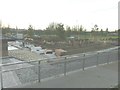
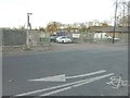
The redevelopment of Drapers Field
Taken late afternoon from High Road Leyton showing the work that is taking place to redevelop this recreation ground. The link shows the masterplan, which is to include the re-siting of the all weather pitch and a planned beach volleyball area http://walthamforestlibdems.mycouncillor.org.uk/2011/07/22/drapers-field-leyton-further-update
Image: © John Baker
Taken: 4 Dec 2013
0.08 miles
7
Drapers Field - an Olympic legacy
Drapers Field has been transformed as part of Waltham Forest Council's Olympic legacy. Drapers Field now offers a variety of sports and play equipment and includes a cycle route, a football pitch, a junior grass football pitch, an under 5's play area, an under 12’s play area, table tennis, a sport pavilion and a cafe.
This photograph looks past the cafe on the right to High Road Leyton beyond where the buses can be seen.
Image: © Marathon
Taken: 14 Jan 2015
0.10 miles
8
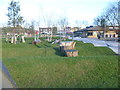
The entrance to Drapers Field
From Temple Mill Lane. The link shows the masterplan for this recreation ground, which is to include the re-siting of the all weather pitch and a planned beach volleyball area http://walthamforestlibdems.mycouncillor.org.uk/2011/07/22/drapers-field-leyton-further-update
Image: © John Baker
Taken: 4 Dec 2013
0.10 miles
9
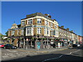
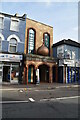
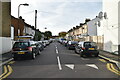
The Leyton Star
The Leyton Star pub on Leyton High Road, in the suburbs of north east London. Leyton High Road forms part of the route of the A112.
Image: © Malc McDonald
Taken: 31 May 2021
0.11 miles