IMAGES TAKEN NEAR TO
Ellingham Road, LONDON, E15 2AU
Introduction
This page details the photographs taken nearby to Ellingham Road, E15 2AU by members of the Geograph project.
The Geograph project started in 2005 with the aim of publishing, organising and preserving representative images for every square kilometre of Great Britain, Ireland and the Isle of Man.

There are currently over 7.5m images from over14,400 individuals and you can help contribute to the project by visiting https://www.geograph.org.uk
Image Map (Loading...)


Getting Data...Please wait
Leaflet Map data © OpenStreetMap
Images are licensed for reuse under creativecommons.org/licenses/by-sa/2.0
Notes
- Clicking on the map will re-center to the selected point.
- The higher the marker number, the further away the image location is from the centre of the postcode.
Image Listing (34 Images Found)
Images are licensed for reuse under creativecommons.org/licenses/by-sa/2.0
Image
Details
Distance
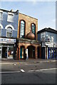
1
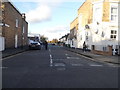
Brydges Road from Chobham Road, Stratford
It is a crossroads divided between both sides of this road.
Image: © David Howard
Taken: 12 Nov 2017
0.03 miles
3
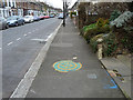
Greenwich Meridian marker, Leslie Road
Rather the worse for wear, but it was placed in 2000 and so is eleven years old in this view. The location scales at a little over 100 m west of the WGS84 prime meridian, which is about right.
Image: © Robin Webster
Taken: 5 Feb 2011
0.13 miles
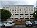
10
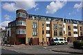
Flats at Chandos Road
At junction with Major Road.
Image: © Oast House Archive
Taken: 2 Aug 2020
0.21 miles