IMAGES TAKEN NEAR TO
Parkway Crescent, LONDON, E15 1AB
Introduction
This page details the photographs taken nearby to Parkway Crescent, E15 1AB by members of the Geograph project.
The Geograph project started in 2005 with the aim of publishing, organising and preserving representative images for every square kilometre of Great Britain, Ireland and the Isle of Man.

There are currently over 7.5m images from over14,400 individuals and you can help contribute to the project by visiting https://www.geograph.org.uk
Image Map (Loading...)


Getting Data...Please wait
Leaflet Map data © OpenStreetMap
Images are licensed for reuse under creativecommons.org/licenses/by-sa/2.0
Notes
- Clicking on the map will re-center to the selected point.
- The higher the marker number, the further away the image location is from the centre of the postcode.
Image Listing (55 Images Found)
Images are licensed for reuse under creativecommons.org/licenses/by-sa/2.0
Image
Details
Distance
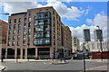
1
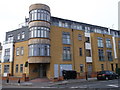
Metro Building, Stratford
Modern apartment building on the junction of Major Road (on the left) and Chandos Road.
Image: © David Anstiss
Taken: 26 Aug 2012
0.02 miles
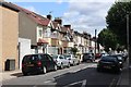
3
Flats at Chandos Road
At junction with Major Road.
Image: © Oast House Archive
Taken: 2 Aug 2020
0.02 miles

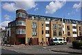
10
Sentinel Building
Built on the site of former Wheelers Pub and adjacent industrial site.
Image: © Oast House Archive
Taken: 2 Aug 2020
0.08 miles