IMAGES TAKEN NEAR TO
Candle Street, LONDON, E1 4RS
Introduction
This page details the photographs taken nearby to Candle Street, E1 4RS by members of the Geograph project.
The Geograph project started in 2005 with the aim of publishing, organising and preserving representative images for every square kilometre of Great Britain, Ireland and the Isle of Man.

There are currently over 7.5m images from over14,400 individuals and you can help contribute to the project by visiting https://www.geograph.org.uk
Image Map
Images are licensed for reuse under creativecommons.org/licenses/by-sa/2.0
Notes
- Clicking on the map will re-center to the selected point.
- The higher the marker number, the further away the image location is from the centre of the postcode.
Image Listing (149 Images Found)
Images are licensed for reuse under creativecommons.org/licenses/by-sa/2.0
Image
Details
Distance
1
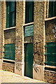
Ragged School Museum
Rare surviving canal-side warehouses in Copperfield Road, once used for one of Dr Barnado's ragged schools.
Image: © Pierre Terre
Taken: 7 May 2005
0.01 miles
2
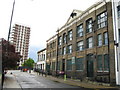
Mile End: The Ragged School Museum, Copperfield Road, E3
Ragged schools were free schools, initially established in the late 1860s by Thomas Barnardo to provide poor children in the East End of London with a free basic education. This building, which was originally a lime juice warehouse on the Regent's Canal, which runs at the rear, became the largest ragged school in London when it opened in 1877. It closed in 1908 as schools provided by the local government authorities were opened. After various industrial uses the buildings were saved from threatened demolition and the Ragged School Museum Charitable Trust was established to create a museum to show today's children what life was like in a Victorian school classroom. The Museum opened in 1990 and its website is here http://www.raggedschoolmuseum.org.uk/nextgen/
The distant towerblock is Waterview House, a 1969 built 16 storey structure on Carr Street, arranged into 66 flats.
(From a technical point of view this is a fine illustration of how distorted tall buildings can apparently become and appear to lean into the photograph.)
Image: © Nigel Cox
Taken: 1 May 2008
0.01 miles
3
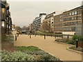
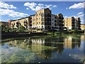
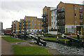
Regent's Canal
Smartly tended walkways and landscaping now border the canal, seen here from Ben Jonson Road at Victory Bridge. On the left is Gray Court. Johnson's Lock is overlooked by flats on Candy Wharf.
Image: © Derek Harper
Taken: 1 Feb 2011
0.01 miles
4
Canalside development
New residential development on the west side of the canal above Ben Jonson Road.
Image: © Natasha Ceridwen de Chroustchoff
Taken: 4 Oct 2009
0.02 miles
5
Residential Flats
Residential flats alongside Regent canal in Mile End.
Image: © Alan Hughes
Taken: 13 Aug 2017
0.03 miles
6
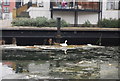
Monopods on the canal
A common sight but why DO water birds stand on one leg? It can't be restful! The answer is heat conservation: such birds possess an adaptation called a "rete mirabilis" a complex web of arteries and veins which in their case acts as a heat exchange mechanism: the arteries that transport warm blood into the legs lie in contact with the veins that return colder blood to the bird’s heart. The arteries warm the veins. By standing on one leg, a bird reduces by half the amount of heat lost through unfeathered limbs and webbed feet.
Image: © Natasha Ceridwen de Chroustchoff
Taken: 4 Oct 2009
0.03 miles
8
The canal north of Ben Jonson Road
New housing developments on the left, on the right the old warehouses that later became one of Dr Barnardo's Ragged Schools, now a museum.
Image: © Natasha Ceridwen de Chroustchoff
Taken: 4 Oct 2009
0.03 miles
9
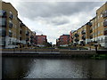
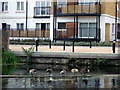
Johnson's Lock
The industry and dereliction that used to surround the Regent's Canal has in many cases given way to residential development such as this.
Image: © David Kemp
Taken: 2 Feb 2011
0.03 miles
10
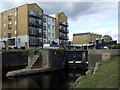
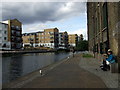
Johnson's lock on the Regent's Canal
A nice juxtapositioning of the old and the new, with the modern flats overlooking the canal.
Image: © Natasha Ceridwen de Chroustchoff
Taken: 4 Oct 2009
0.04 miles