IMAGES TAKEN NEAR TO
Harford Street, LONDON, E1 4RH
Introduction
This page details the photographs taken nearby to Harford Street, E1 4RH by members of the Geograph project.
The Geograph project started in 2005 with the aim of publishing, organising and preserving representative images for every square kilometre of Great Britain, Ireland and the Isle of Man.

There are currently over 7.5m images from over14,400 individuals and you can help contribute to the project by visiting https://www.geograph.org.uk
Image Map
Images are licensed for reuse under creativecommons.org/licenses/by-sa/2.0
Notes
- Clicking on the map will re-center to the selected point.
- The higher the marker number, the further away the image location is from the centre of the postcode.
Image Listing (209 Images Found)
Images are licensed for reuse under creativecommons.org/licenses/by-sa/2.0
Image
Details
Distance
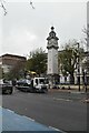
4
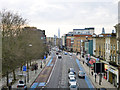
The Mile End Road
In the distance is The Shard by London Bridge station.
Image: © Robin Webster
Taken: 18 Jan 2014
0.03 miles
7
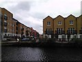
View along White Tower Way from the Regents Canal towpath
Looking west. The tip of the Gherkin can be seen in the distance.
Image: © Robert Lamb
Taken: 24 Apr 2012
0.04 miles

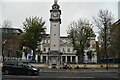
9
St Benet's Chapel, Queen Mary University
Image: © N Chadwick
Taken: 20 Nov 2022
0.05 miles
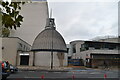
10
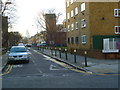
Looking into Ernest Street from the east
In the distance is "The Gherkin".
Image: © Shazz
Taken: 9 Jan 2014
0.05 miles