IMAGES TAKEN NEAR TO
Ibbott Street, LONDON, E1 4JS
Introduction
This page details the photographs taken nearby to Ibbott Street, E1 4JS by members of the Geograph project.
The Geograph project started in 2005 with the aim of publishing, organising and preserving representative images for every square kilometre of Great Britain, Ireland and the Isle of Man.

There are currently over 7.5m images from over14,400 individuals and you can help contribute to the project by visiting https://www.geograph.org.uk
Image Map
Images are licensed for reuse under creativecommons.org/licenses/by-sa/2.0
Notes
- Clicking on the map will re-center to the selected point.
- The higher the marker number, the further away the image location is from the centre of the postcode.
Image Listing (110 Images Found)
Images are licensed for reuse under creativecommons.org/licenses/by-sa/2.0
Image
Details
Distance
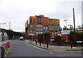
1
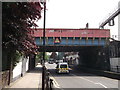
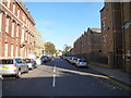
Globe Road railway bridge, Bethnal Green
Globe Road leads from Roman Road to Mile End Road.
It passes under the railway line between Bethnal Green and Stratford.
Image: © David Anstiss
Taken: 23 May 2012
0.05 miles
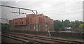
2
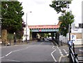
Bethnal Green, railway bridge
Carrying the Liverpool Street to Stratford mainline over Globe Road.
Image: © Mike Faherty
Taken: 26 Aug 2012
0.05 miles
3
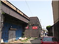
Railway Arches, Bethnal Green
Row of business units under the arches of the Bethnal Green to Stratford Railway line.
Image: © David Anstiss
Taken: 23 May 2012
0.06 miles
4
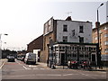
Railway Tavern, Bethnal Green
Public house on the junction of Globe Road (in front) and Portman Place (on the left).
On the far left is the railway line.
Image: © David Anstiss
Taken: 23 May 2012
0.06 miles
5
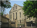
Church on Cephas Street
Looking north up Cephas Avenue from the Mile End Road junction.
Image: © Robert Lamb
Taken: 21 Oct 2011
0.06 miles
6
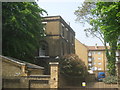
St. Peter's Vicarage, Bethnal Green
Grade II listed house beside St.Peter's Church.
See http://www.britishlistedbuildings.co.uk/en-205841-st-peter-s-vicarage-bethnal-green for more details about the building.
Image: © David Anstiss
Taken: 23 May 2012
0.06 miles
8
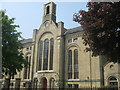
St Peter's Church, Bethnal Green
Grade II listed church on Cephas Street.
See http://www.britishlistedbuildings.co.uk/en-205843-st-peter-s-church-bethnal-green for more details on the building.
Has been converted into housing.
Image: © David Anstiss
Taken: 23 May 2012
0.07 miles
9
St Peter's Church Sunday School
Grade II listed building beside St Peter's Church. It is also St. Peter's Social Club, Stepney
See http://www.britishlistedbuildings.co.uk/en-206399-st-peter-s-church-sunday-school-st-peter for more details about the building.
Image: © David Anstiss
Taken: 23 May 2012
0.07 miles
10
Bethnal Green, sixth form centre
Wessex Campus, Cambridge Heath Sixth Form Centre; in a former School Board for London building on Hadleigh Street. http://www.cambridgeheath.towerhamlets.sch.uk/The-Wessex-Centre
Image: © Mike Faherty
Taken: 1 Sep 2012
0.07 miles