IMAGES TAKEN NEAR TO
Bradwell Street, LONDON, E1 4GP
Introduction
This page details the photographs taken nearby to Bradwell Street, E1 4GP by members of the Geograph project.
The Geograph project started in 2005 with the aim of publishing, organising and preserving representative images for every square kilometre of Great Britain, Ireland and the Isle of Man.

There are currently over 7.5m images from over14,400 individuals and you can help contribute to the project by visiting https://www.geograph.org.uk
Image Map
Images are licensed for reuse under creativecommons.org/licenses/by-sa/2.0
Notes
- Clicking on the map will re-center to the selected point.
- The higher the marker number, the further away the image location is from the centre of the postcode.
Image Listing (181 Images Found)
Images are licensed for reuse under creativecommons.org/licenses/by-sa/2.0
Image
Details
Distance
1
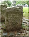
Old Boundary Marker in Meath Gardens, Stepney Parish
Parish Boundary Marker in the parish of Stepney (Tower Hamlets District), Meath Gardens E2, Southern boundary of park, reset with 2 BG stones in brick circle.
Surveyed
Milestone Society National ID: MX_MEOT02pb.
Image: © Milestone Society
Taken: Unknown
0.07 miles
2
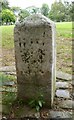
Old Boundary Marker in Meath Gardens, Bethnal Green Parish
Parish Boundary Marker in parish of Bethnal Green (Tower Hamlets District), Meath Gardens E2, Southern boundary of park, reset with 2 BG stones in brick circle.
Surveyed
Milestone Society National ID: MX_SMBG04pb
Image: © Milestone Society
Taken: Unknown
0.07 miles
3
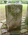
Old Boundary Marker in Meath Gardens, Bethnal Green
Parish Boundary Marker in parish of Bethnal Green (Tower Hamlets District), Meath Gardens E2, Southern boundary of park, reset with 2 BG stones in brick circle.
Surveyed
Milestone Society National ID: MX_SMBG03pb
Image: © Milestone Society
Taken: Unknown
0.07 miles
4

Timber sheds, Globe town
Once a common sight on London's waterways from the Surrey Docks to Edmonton, these overhanging timber sheds await development.
[Edit] Demolished mid 2007
Image: © Pierre Terre
Taken: 7 May 2005
0.10 miles
5
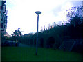
Car park and railway arches, viewed from the Regent's Canal path
Looking south-southwest.
Image: © Robert Lamb
Taken: 18 Nov 2010
0.10 miles
6
Railway viaduct behind the Queen Mary University Student Residences
I thought I'd just pass the time away whilst I had a spare moment after my lunch break taking a walk around the campus of Queen Mary and taking some "behind-the-scenes" photos. If you walk all the way up the Regents Canal path adjacent to the student residences at Queen Mary to the GER bridge and look left, you get a view of these brick arches carrying the railway as well as a small green, leading to the bins for the nearby halls of residence and a small car park beyond. This is actually as far as you can go into the top-left hand corner of this square (on this side of the railway, anyway). Not the most exciting of views, but an interesting one all the same. View taken looking north-northeast towards Globe Town on the other side of the railway.
Image: © Robert Lamb
Taken: 26 Oct 2009
0.11 miles
7
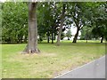
Bethnal Green, Meath Gardens
Former cemetery, now open space with children's centre and playground. http://www.londongardensonline.org.uk/gardens-online-record.asp?ID=THM028
Image: © Mike Faherty
Taken: 1 Sep 2012
0.11 miles
8
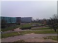
View of Globe Town from the mound in Mile End Park
Looking northwest. A Liverpool Street-Shenfield train can be seen crossing the bridge over the Regent's Canal in the middle distance, whilst Sir Christopher France House (turquoise building, one of Queen Mary University of London's student residence blocks) can be seen to the left.
Image: © Robert Lamb
Taken: 2 Mar 2012
0.12 miles
9
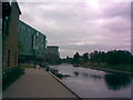
View looking north-northwest along Regent's Canal from Queen Mary University
I've just started my first year of studying at Queen Mary University as an undergraduate, so as a little celebration I thought I'd upload some pictures of Regent's Canal, which flows behind the halls of residence just to the right of the main entrance from Mile End Road. This is the view looking north-northwest along the canal towards Hackney. The Great Eastern Railway between Stratford and Liverpool Street crosses the canal on a small bridge in the background just behind the turquoise residences building.
Image: © Robert Lamb
Taken: 28 Sep 2009
0.12 miles
10

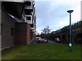
View of the Queens Building from the student village
This is the Queens Building, the oldest building in Queen Mary University, constructed in the 1930s after the original building caught fire in 1931. It was then known as St Helen's Terrace, a row of six houses neighbouring the original site of the Queens Building. View taken looking across the car park from the 'student village'.
Image: © Robert Lamb
Taken: 26 Oct 2009
0.12 miles