IMAGES TAKEN NEAR TO
Nicholas Road, LONDON, E1 4AZ
Introduction
This page details the photographs taken nearby to Nicholas Road, E1 4AZ by members of the Geograph project.
The Geograph project started in 2005 with the aim of publishing, organising and preserving representative images for every square kilometre of Great Britain, Ireland and the Isle of Man.

There are currently over 7.5m images from over14,400 individuals and you can help contribute to the project by visiting https://www.geograph.org.uk
Image Map
Images are licensed for reuse under creativecommons.org/licenses/by-sa/2.0
Notes
- Clicking on the map will re-center to the selected point.
- The higher the marker number, the further away the image location is from the centre of the postcode.
Image Listing (180 Images Found)
Images are licensed for reuse under creativecommons.org/licenses/by-sa/2.0
Image
Details
Distance
1
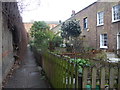
Mile End Place
This quiet little courtyard is entered through a small archway off the north side of Mile End Road see Image The cottages were built in the mid 1860s
Image: © Derek Voller
Taken: Unknown
0.05 miles
2
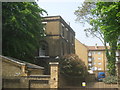
St. Peter's Vicarage, Bethnal Green
Grade II listed house beside St.Peter's Church.
See http://www.britishlistedbuildings.co.uk/en-205841-st-peter-s-vicarage-bethnal-green for more details about the building.
Image: © David Anstiss
Taken: 23 May 2012
0.09 miles
3
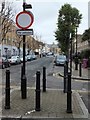
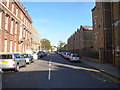
Traffic barrier in Cephas Avenue
The sign at the end of this residential street says "No vehicles" which means (UK Highway Code) that cycles must be pushed by hand; however it is alongside a cycle track. At the end of Cephas Avenue is St Peter's Court (Cephas and Peter are the two names Jesus gave to his disciple)
Image: © David Smith
Taken: 20 Nov 2012
0.10 miles
4
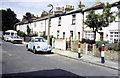
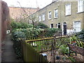
Bellevue Place
Geoffrey Fletcher wrote in 'The London Nobody Knows' in 1962: "Bellevue Place is off Stepney Green, down a little street. A green gate opening in the wall leads to a totally unexpected corner of London. Bellevue Place is well named. It is a cul-de-sac with a paved pathway leading to the far end, under a creeper-covered wall. The cottages are early nineteenth century, and have true cottage gardens fenced with wooden rails, pointed at the top. Here are unbelievably rural gardens, full of lilac, roses, hydrangeas, wallflowers, lupins, and delphiniums – all a minute’s walk from the Mile End Road."
Amazingly when so much else has changed, well over half a century later Bellevue Place is unchanged. It still has the green gate in Cleveland Way as at https://www.geograph.org.uk/photo/6055563, which leads beyond the gate to the cottages seen here.
Image: © Marathon
Taken: 6 Feb 2019
0.10 miles
5
Bellevue Place
Geoffrey Fletcher wrote in 'The London Nobody Knows' in 1962: "Bellevue Place is off Stepney Green, down a little street. A green gate opening in the wall leads to a totally unexpected corner of London. Bellevue Place is well named. It is a cul-de-sac with a paved pathway leading to the far end, under a creeper-covered wall. The cottages are early nineteenth century, and have true cottage gardens fenced with wooden rails, pointed at the top. Here are unbelievably rural gardens, full of lilac, roses, hydrangeas, wallflowers, lupins, and delphiniums – all a minute’s walk from the Mile End Road."
Amazingly when so much else has changed, well over half a century later Bellevue Place is unchanged. It still has the green gate in Cleveland Way as at https://www.geograph.org.uk/photo/6055563, which leads beyond the gate to the cottages seen here.
Image: © Marathon
Taken: 6 Feb 2019
0.10 miles
6
St Peter's Church Sunday School
Grade II listed building beside St Peter's Church. It is also St. Peter's Social Club, Stepney
See http://www.britishlistedbuildings.co.uk/en-206399-st-peter-s-church-sunday-school-st-peter for more details about the building.
Image: © David Anstiss
Taken: 23 May 2012
0.10 miles
7
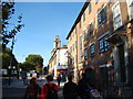
View of the Empire Music Hall from Mile End Road
Looking west-northwest.
Image: © Robert Lamb
Taken: 21 Oct 2011
0.10 miles
8

Entrance to the Anchor Retail Park
The retail park is named after the Anchor Brewery which was founded in 1738 and developed into Charrington and Company. The brewery closed in 1975. See https://maps.nls.uk/view/103313024#zoom=7&lat=10169&lon=3530&layers=BT for an 1875 map of the area.
Image: © Bikeboy
Taken: 24 Dec 2012
0.10 miles
9
Church on Cephas Street
Looking north up Cephas Avenue from the Mile End Road junction.
Image: © Robert Lamb
Taken: 21 Oct 2011
0.11 miles
10
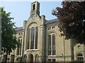
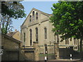
St Peter's Church, Bethnal Green
Grade II listed church on Cephas Street.
See http://www.britishlistedbuildings.co.uk/en-205843-st-peter-s-church-bethnal-green for more details on the building.
Has been converted into housing.
Image: © David Anstiss
Taken: 23 May 2012
0.11 miles