IMAGES TAKEN NEAR TO
Epping Close, LONDON, E14 9WG
Introduction
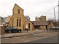
This page details the photographs taken nearby to Epping Close, E14 9WG by members of the Geograph project.
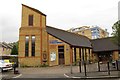
The Geograph project started in 2005 with the aim of publishing, organising and preserving representative images for every square kilometre of Great Britain, Ireland and the Isle of Man.

There are currently over 7.5m images from over14,400 individuals and you can help contribute to the project by visiting https://www.geograph.org.uk
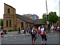
Image Map
Images are licensed for reuse under creativecommons.org/licenses/by-sa/2.0
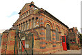
Notes
- Clicking on the map will re-center to the selected point.
- The higher the marker number, the further away the image location is from the centre of the postcode.
Image Listing (106 Images Found)
Images are licensed for reuse under creativecommons.org/licenses/by-sa/2.0
Image
Details
Distance
1
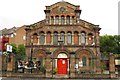
St Edmund's Catholic Church on Westferry Road
Image: © Steve Daniels
Taken: 6 Sep 2013
0.06 miles
2
St Edmund's church, Millwall
The modern Roman Catholic church, completed in 2000, is on Westferry Road, almost opposite Image, on the site of a former church demolished in 1994.
Image: © Derek Harper
Taken: 2 Feb 2011
0.07 miles
3
St Edmund's Catholic Church, Millwall
This church building was erected in 2000, replacing one of 1874.
Photographed during the 2019 London Marathon.
Image: © Stephen Craven
Taken: 28 Apr 2019
0.07 miles
4
Former St.Paul's Presbyterian Church
Grade II listed, Italianate / Romanesque St.Paul's Presbyterian church by T.E.Knightly 1859 on Westferry Road. Now The Space (St.Paul's Arts Centre) and Hubbub bar & restaurant.
Image: © Richard Croft
Taken: 19 Jul 2015
0.08 miles
5
The Space on Westferry Road
The Space is a performing arts centre based in a converted church on the Isle of Dogs.
Image: © Steve Daniels
Taken: 6 Sep 2013
0.08 miles
6
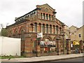
The Space, Westferry Road, E14
A performing arts and community centre in a converted church. St Paul's was built in 1859 and ceased to be a church in 1972. As explained in the detailed history at http://space.org.uk/?page_id=28 , the church is the earliest known example of the use of laminated timber instead of roof trusses. The architect was Thomas Knightley.
The listed building description is at http://www.britishlistedbuildings.co.uk/en-206343-formerly-st-pauls-presbyterian-church-no . "There is a tradition that St Paul's was built to serve the needs of Scottish ironworkers brought to work on the Great Eastern." As the listing also points out, the style is highly reminiscent of the North Italian Romanesque.
Image: © Derek Harper
Taken: 2 Feb 2011
0.09 miles
7
Former St Paul's Church, Millwall
This Presbyterian church building was erected in 1859, architect T E Knightly. Its polychromatic brick style is unusual for non-conformist churches of the time, as is the denomination in an area dominated by Roman or Anglo-Catholic churches. According to the listing (Grade II, list entry 1065817) "there is a tradition that St Paul's was built to serve the needs of Scottish ironworkers brought to work on the Great Eastern."
After closure, at one time it was in industrial use but is now "Hubbub" cafe bar.
Photographed during the 2019 London Marathon, hence the spectators and bunting.
Image: © Stephen Craven
Taken: 28 Apr 2019
0.09 miles
8
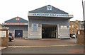
Vanguard Storage, Westferry Road
One of the firm's three locations; the others are in Greenford and Manchester.
Image: © Derek Harper
Taken: 2 Feb 2011
0.09 miles
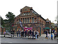
9
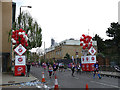
Sixteen miles into the Marathon
The junction of Westferry Road and Crews Street, during the 2019 London Marathon.
Image: © Stephen Craven
Taken: 28 Apr 2019
0.10 miles
10
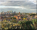
View from The Point (1)
View north towards Canary Wharf (left) and the Dome (right).
The Point is one of thirteen protected views in London because of its sightline to St Paul's.
Image: © Stephen Richards
Taken: 3 Oct 2017
0.11 miles