IMAGES TAKEN NEAR TO
Bridge House Quay, LONDON, E14 9QW
Introduction
This page details the photographs taken nearby to Bridge House Quay, E14 9QW by members of the Geograph project.
The Geograph project started in 2005 with the aim of publishing, organising and preserving representative images for every square kilometre of Great Britain, Ireland and the Isle of Man.

There are currently over 7.5m images from over14,400 individuals and you can help contribute to the project by visiting https://www.geograph.org.uk
Image Map
Images are licensed for reuse under creativecommons.org/licenses/by-sa/2.0
Notes
- Clicking on the map will re-center to the selected point.
- The higher the marker number, the further away the image location is from the centre of the postcode.
Image Listing (334 Images Found)
Images are licensed for reuse under creativecommons.org/licenses/by-sa/2.0
Image
Details
Distance
1
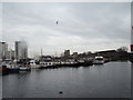
View over Poplar Dock
Looking south-southeast.
Image: © Robert Lamb
Taken: 24 Nov 2012
0.01 miles
2
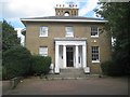
Blackwall: Bridge House, 24 - 26 Preston's Road
Bridge House was designed by the engineer John Rennie and was completed in 1819 as a home for the Superintendent of the West India Dock Company. It was originally symmetrical, with bow windows on both the east and west sides, but an extension was later built on the north side. This is the south side. After surviving the wartime bombing it became a police training college in the 1950s and was subsequently occupied by the London Federation of Boys' Clubs. It is a Grade II Listed Building. Note the interesting chimney arrangement.
Image: © Nigel Cox
Taken: 6 Sep 2018
0.01 miles
4
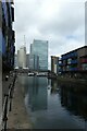
Blackwall Basin entrance
Looking along the entrance lock into Blackwall Basin from a footbridge.
Image: © DS Pugh
Taken: 2 Aug 2022
0.01 miles
5

Looking toward Canary Wharf from Emirates Air Line cable car
Image: © PAUL FARMER
Taken: 1 Jul 2012
0.02 miles
6
Blackwall Basin Lock
Looking along the south side of the entrance basin.
Image: © DS Pugh
Taken: 2 Aug 2022
0.02 miles
7
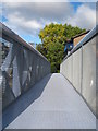
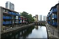
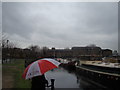
Footbridge at Blackwall Basin
Linking the housing development on each side of the lock.
Image: © Rod Allday
Taken: 16 Oct 2010
0.03 miles
8
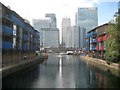
Blackwall: Former New Blackwall Entrance (2)
The New Blackwall Entrance was at one time the first entrance into the West India Docks complex for ships coming upstream along the River Thames. It was once a single lock but later a double lock, with the uppermost lock gate just this side of where the footbridge is now. Today the entrance is sealed and non-navigable. This is the view looking into Blackwall Basin, once the West India Dock Basin, with Canary Wharf beyond.
Image: © Nigel Cox
Taken: 6 Sep 2018
0.03 miles
9
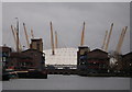
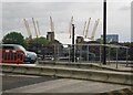
Marina near Billingsgate
Old wharves in use as a marina with the Millennium Dome in the background.
Image: © Simon Leatherdale
Taken: 29 Dec 2006
0.03 miles
10
View of dockside houses from Poplar Dock
Looking south-southwest.
Image: © Robert Lamb
Taken: 24 Nov 2012
0.03 miles