IMAGES TAKEN NEAR TO
Millharbour, LONDON, E14 9HB
Introduction
This page details the photographs taken nearby to Millharbour, E14 9HB by members of the Geograph project.
The Geograph project started in 2005 with the aim of publishing, organising and preserving representative images for every square kilometre of Great Britain, Ireland and the Isle of Man.

There are currently over 7.5m images from over14,400 individuals and you can help contribute to the project by visiting https://www.geograph.org.uk
Image Map (Loading...)


Getting Data...Please wait
Leaflet Map data © OpenStreetMap
Images are licensed for reuse under creativecommons.org/licenses/by-sa/2.0
Notes
- Clicking on the map will re-center to the selected point.
- The higher the marker number, the further away the image location is from the centre of the postcode.
Image Listing (347 Images Found)
Images are licensed for reuse under creativecommons.org/licenses/by-sa/2.0
Image
Details
Distance
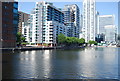
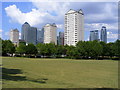
2

Millwall Inner Dock, Isle of Dogs E14
Canary Wharf looms in the background
Image: © Philip Talmage
Taken: 18 Nov 2005
0.03 miles
3
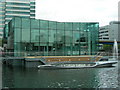
Pan Peninsula Marketing Suite
This is a floating, semi permanent site which will probably be used for something else once the apartments in Pan Peninsula Image have been sold. Prospective buyers might get a ride out into Millwall Dock in the expensive looking boat, seen in the foreground. Little expense is being spared marketing these flats and it does give an indication of the type of customer that the developer has in mind.
Image: © Danny P Robinson
Taken: 19 May 2007
0.03 miles
4
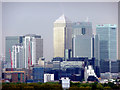
Greenwich Panorama
Looking across towards the Isle of Dogs from Greenwich Park not far from the Observatory. The Canary Wharf towers dominate the view.
Image: © Christine Matthews
Taken: 28 Apr 2009
0.03 miles
5
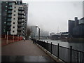
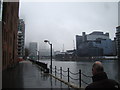
View of buildings in South Quay from Millwall Dock
Looking north.
Image: © Robert Lamb
Taken: 24 Nov 2012
0.03 miles
6
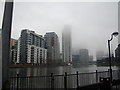
View up Millwall Dock towards South Quay
Looking north.
Image: © Robert Lamb
Taken: 24 Nov 2012
0.03 miles
7
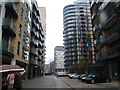
View of buildings in Millharbour from Oakland Quay
Looking north-northwest.
Image: © Robert Lamb
Taken: 24 Nov 2012
0.04 miles
8
View of buildings in Millharbour from Millwall Dock
Looking west.
Image: © Robert Lamb
Taken: 24 Nov 2012
0.04 miles
9
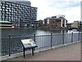
Millwall Dock
Millwall Dock, in London's Docklands.
Millwall Dock opened in 1868. During the 1960s and 1970s, the docks gradually closed, replaced by container ports and air freight. After a period of lying derelict, London's Docklands were transformed by regeneration.
The lifting bridge to the right of the image was built to carry a road across the working dock. The large block of apartments is a far more recent addition to the scene.
Image: © Malc McDonald
Taken: 7 Jun 2011
0.04 miles
10
Docklands skyline
In little more than a couple of decades, the docklands skyline has changed far beyond anything that the original occupants could have dreamed possible. It's gone from a mix of low rise, run down industrial and residential buildings, to high rise, high tec sky-scrapers occupied by highly paid, high living, successful people. The area bears more resemblance to Manhattan than Millwall.
Image: © Derek Voller
Taken: 1 Jun 2008
0.05 miles