1
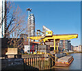
Blackwall Tunnel ventilation shaft
Ventilation shaft from the Blackwall Tunnel.
Image: © Malc McDonald
Taken: 3 May 2010
0.02 miles
2
Accumulator tower, Poplar Dock
This is one of two remote hydraulic accumulator towers in the Poplar Dock area. This one is on Prestons Road and dates from 1878 and the other is from 1875 and by the new Billingsgate. These were for the London & North Western Railway. The supplying pumping station has been demolished.
Image: © Chris Allen
Taken: 21 Aug 2011
0.02 miles
3
The River Thames at Blackwall
Coldharbour is on the river With the towers of Canary Wharf in the background
Image: © Glyn Baker
Taken: 29 Apr 2017
0.03 miles
4
Blackwall: Poplar Dock Accumulator Tower (1 of 2)
A hydraulic accumulator tower is a pressure storage reservoir in which a non-compressible hydraulic fluid is held under pressure that is applied by an external source. The external source can be a spring, a raised weight, or a compressed gas. An accumulator enables a hydraulic system to cope with extremes of demand using a less powerful pump, to respond more quickly to a temporary demand, and to smooth out pulsations.
This one was built out of stock brick in the 1870s, and is now a Grade II Listed structure.
Preston's Road is in the background.
Image: © Nigel Cox
Taken: 6 Sep 2018
0.03 miles
5
Blackwall : Northumberland Wharf waste transfer station
Image: © Jim Osley
Taken: 9 Mar 2021
0.04 miles
6
Blackwall Basin
Outlet from Blackwall Basin into the Thames. Across the river is the Millennium Dome (now the O2).
Image: © Malc McDonald
Taken: 3 May 2010
0.05 miles
7
Isle of Dogs Evening
Across the river from the Thames Path as it passes the O2 Dome, the lights are coming on.
Image: © Trevor Harris
Taken: 7 Feb 2009
0.05 miles
8
View of dockside houses from Poplar Dock
Looking south-southwest.
Image: © Robert Lamb
Taken: 24 Nov 2012
0.05 miles
9
View of Northumberland Wharf from Preston's Road
Northumberland Wharf is the location of Tower Hamlets' recycling centre. Looking south-southeast.
Image: © Robert Lamb
Taken: 24 Nov 2012
0.05 miles
10
Blackwall: Bridge House, 24 - 26 Preston's Road
Bridge House was designed by the engineer John Rennie and was completed in 1819 as a home for the Superintendent of the West India Dock Company. It was originally symmetrical, with bow windows on both the east and west sides, but an extension was later built on the north side. This is the south side. After surviving the wartime bombing it became a police training college in the 1950s and was subsequently occupied by the London Federation of Boys' Clubs. It is a Grade II Listed Building. Note the interesting chimney arrangement.
Image: © Nigel Cox
Taken: 6 Sep 2018
0.05 miles


