IMAGES TAKEN NEAR TO
Midship Point, The Quarterdeck, LONDON, E14 8SW
Introduction
This page details the photographs taken nearby to Midship Point, The Quarterdeck, E14 8SW by members of the Geograph project.
The Geograph project started in 2005 with the aim of publishing, organising and preserving representative images for every square kilometre of Great Britain, Ireland and the Isle of Man.

There are currently over 7.5m images from over14,400 individuals and you can help contribute to the project by visiting https://www.geograph.org.uk
Image Map
Images are licensed for reuse under creativecommons.org/licenses/by-sa/2.0
Notes
- Clicking on the map will re-center to the selected point.
- The higher the marker number, the further away the image location is from the centre of the postcode.
Image Listing (216 Images Found)
Images are licensed for reuse under creativecommons.org/licenses/by-sa/2.0
Image
Details
Distance

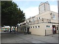
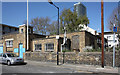
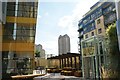
4
View of The Landmark Apartments and a towerblock in the Quarterdeck development from Westferry Road
Looking north-northeast.
Image: © Robert Lamb
Taken: 13 Aug 2017
0.06 miles
5
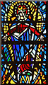
St Luke, Havannah Street, Millwall - Stained glass window
Image: © John Salmon
Taken: 8 Apr 2011
0.06 miles
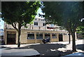
7
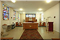
St Luke, Havannah Street, Millwall - Chancel
Image: © John Salmon
Taken: 8 Apr 2011
0.07 miles
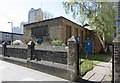
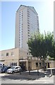
9
View of a towerblock in the Quarterdeck development from Marsh Wall
Looking south-southwest.
Image: © Robert Lamb
Taken: 13 Aug 2017
0.07 miles