IMAGES TAKEN NEAR TO
Byng Street, LONDON, E14 8GF
Introduction
This page details the photographs taken nearby to Byng Street, E14 8GF by members of the Geograph project.
The Geograph project started in 2005 with the aim of publishing, organising and preserving representative images for every square kilometre of Great Britain, Ireland and the Isle of Man.

There are currently over 7.5m images from over14,400 individuals and you can help contribute to the project by visiting https://www.geograph.org.uk
Image Map
Images are licensed for reuse under creativecommons.org/licenses/by-sa/2.0
Notes
- Clicking on the map will re-center to the selected point.
- The higher the marker number, the further away the image location is from the centre of the postcode.
Image Listing (314 Images Found)
Images are licensed for reuse under creativecommons.org/licenses/by-sa/2.0
Image
Details
Distance
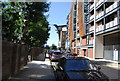
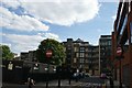
1
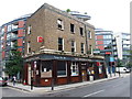
Millwall Fire Station, Isle of Dogs
Modern fire station, part of the large apartment development around the station.
Offices of Heron Quay overlook the station, slightly obscurred by the fading fog!
Image: © David Anstiss
Taken: 20 Nov 2011
0.01 miles
2
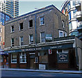
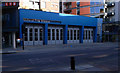
Derelict public house, Millwall
One of the few buildings to have survived the comprehensive development of Canary Wharf and its environs, but not for much longer!
Image: © Jim Osley
Taken: 6 Apr 2013
0.02 miles
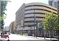
3
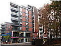
Apartments and restaurant, Byng Street
This large modern development is between Byng Street and Manilla Street.
The restaurant also faces Westferry Road.
Image: © David Anstiss
Taken: 20 Nov 2011
0.02 miles
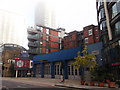
4
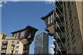
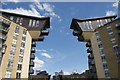
View of Marlin Apartments from the Thames Path
Looking north-northeast in the gap between the balconies of two blocks of apartments in the Millennium Harbour residential development.
Image: © Robert Lamb
Taken: 13 Aug 2017
0.02 miles
5
Millwall Fire Station, Isle of Dogs
Opened January 2006 http://www.london-fire.gov.uk/news/NewsArchive2006_11Jan06.asp
Image: © Jim Osley
Taken: 6 Apr 2013
0.02 miles
7
View of Phoenix Heights West from the Thames Path
Looking east through the gap in between two balconies of blocks of flats in the Millennium Harbour residential development.
Image: © Robert Lamb
Taken: 13 Aug 2017
0.03 miles
8
View of apartments on Manilla Street from Tobago Street
Looking south.
Image: © Robert Lamb
Taken: 13 Aug 2017
0.03 miles