IMAGES TAKEN NEAR TO
Narrow Street, LONDON, E14 8DQ
Introduction
This page details the photographs taken nearby to Narrow Street, E14 8DQ by members of the Geograph project.
The Geograph project started in 2005 with the aim of publishing, organising and preserving representative images for every square kilometre of Great Britain, Ireland and the Isle of Man.

There are currently over 7.5m images from over14,400 individuals and you can help contribute to the project by visiting https://www.geograph.org.uk
Image Map
Images are licensed for reuse under creativecommons.org/licenses/by-sa/2.0
Notes
- Clicking on the map will re-center to the selected point.
- The higher the marker number, the further away the image location is from the centre of the postcode.
Image Listing (415 Images Found)
Images are licensed for reuse under creativecommons.org/licenses/by-sa/2.0
Image
Details
Distance
1
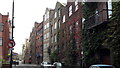
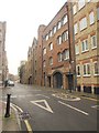
Narrow Street, Limehouse
Narrow Street is the outermost of its type on the left bank of the Thames in London, a street behind the warehouses built along the river. Below it the pattern breaks down around the Isle of Dogs.
Image: © Chris Brown
Taken: 22 Oct 2017
0.00 miles
6
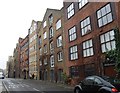
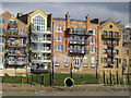
Narrow Street
Looking past the junction with Spert Street; warehouses converted into flats separate the street from the River Thames to the right.
Image: © Derek Harper
Taken: 1 Feb 2011
0.02 miles
7
Ratcliffe CSO outfall
This circular brick culvert (estimated at 8 feet diameter using the couple on the balcony as a guide) discharges to the north side of the Thames below high tide level, near the western end of Horseferry Road. It is known as the Ratcliffe CSO (combined sewer overflow). The proposed Thames Tideway Tunnel (deep interceptor sewer) will leave the route of the river near here, but Ratcliffe CSO is not one of the ones being intercepted, as statistics showed it did not operate at all in 2011 and is therefore classified as of low environmental impact.
Image: © Stephen Craven
Taken: 12 Oct 2013
0.02 miles
8

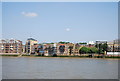
View of the Walkie Talkie, Heron Tower and Gherkin from Canary Riverside
Looking north-northwest.
Image: © Robert Lamb
Taken: 31 Jul 2016
0.02 miles
9
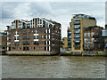
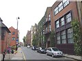
Ratcliffe Cross Stairs
The gap between Keepier Wharf on the left and Phoenix Wharf is where the stairs give access to the river from Narrow Street.
Image: © Robin Webster
Taken: 30 Jun 2011
0.02 miles
10

View of the Walkie Talkie, Heron Tower and Gherkin from Canary Riverside #2
Looking north-northwest.
Image: © Robert Lamb
Taken: 31 Jul 2016
0.03 miles