IMAGES TAKEN NEAR TO
Brenton Street, LONDON, E14 7PY
Introduction
This page details the photographs taken nearby to Brenton Street, E14 7PY by members of the Geograph project.
The Geograph project started in 2005 with the aim of publishing, organising and preserving representative images for every square kilometre of Great Britain, Ireland and the Isle of Man.

There are currently over 7.5m images from over14,400 individuals and you can help contribute to the project by visiting https://www.geograph.org.uk
Image Map
Images are licensed for reuse under creativecommons.org/licenses/by-sa/2.0
Notes
- Clicking on the map will re-center to the selected point.
- The higher the marker number, the further away the image location is from the centre of the postcode.
Image Listing (315 Images Found)
Images are licensed for reuse under creativecommons.org/licenses/by-sa/2.0
Image
Details
Distance
1
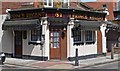
"Prince Regent" public house, Limehouse, London E14
Image: © Jim Osley
Taken: 16 May 2015
0.03 miles
2
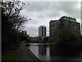
Flats on Carr Street, viewed from the Regent's Canal
Looking north-northeast. Anglia House (photographed in Image) can be seen at the left of the image.
Image: © Robert Lamb
Taken: 24 Apr 2012
0.04 miles
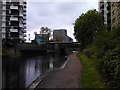
3
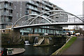
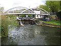
Narrowboat at Salmon Lane lock
Tieing up the boat prior to operating the lock.
The footbridge by Buro Happold, replacing an earlier one, "spans just over 20m and has been designed for cyclist and pedestrian use with an asphalt surfacing. The use of twin steel arches accentuates the curved profile and results in a striking elevation. The structure is equipped with under-deck lighting and is supported on the refurbished brick abutments."
Image: © Natasha Ceridwen de Chroustchoff
Taken: 4 Oct 2009
0.05 miles
4
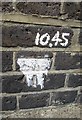
Ordnance Survey Cut Mark
This OS cut mark can be found on the railway bridge at the junction of Yorkshire Road and Salmon Lane. It marks a point 10.446m above mean sea level.
Image: © Adrian Dust
Taken: 16 Aug 2016
0.05 miles
5
View of Anglia House, Salmon Lane from the Regent's Canal
Looking south-southwest.
Image: © Robert Lamb
Taken: 24 Apr 2012
0.05 miles
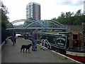
6
Salmon Lane Lock
This shows the southern entrance to the lock. Lascar Wharf Building can be seen on the left and the footbridge carries Parnham Street over the Regent's Canal.
Image: © David Kemp
Taken: 2 Feb 2011
0.05 miles
7
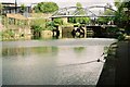
Salmon Lane Lock
Regent's Canal below Salmon Lane Lock, with New Parnham St footbridge completed in Feb 2005.
Image: © Pierre Terre
Taken: 7 May 2005
0.05 miles
8
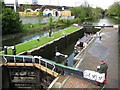
Regent's Canal: Salmon Lane Lock
Salmon Lane Lock is a double lock and Lock Number 11 from Little Venice at Paddington. The near bottom lock gates are new, having been replaced in 2007.
Image: © Nigel Cox
Taken: 1 May 2008
0.05 miles
9
Regent's Canal: Parnham Street Footbridge
The footbridge was commissioned in 2003 to replace an older crossing. An ancient footpath crosses the canal here, leading from Limehouse to St Dunstan’s Church. It passed through a field belonging to a nineteenth century land owner, a Mr Parnham. Today the footbridge joins Parnham Street with Carr Street and Repton Street. Image can be seen under the footbridge.
Image: © Nigel Cox
Taken: 1 May 2008
0.05 miles
10
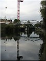
Parnham Street footbridge
Parnham Street footbridge over the Regent's canal by Salmon Lane lock with further redevelopment underway
Image: © Shaun Ferguson
Taken: 24 Sep 2008
0.06 miles