IMAGES TAKEN NEAR TO
York Square, LONDON, E14 7LU
Introduction
This page details the photographs taken nearby to York Square, E14 7LU by members of the Geograph project.
The Geograph project started in 2005 with the aim of publishing, organising and preserving representative images for every square kilometre of Great Britain, Ireland and the Isle of Man.

There are currently over 7.5m images from over14,400 individuals and you can help contribute to the project by visiting https://www.geograph.org.uk
Image Map
Images are licensed for reuse under creativecommons.org/licenses/by-sa/2.0
Notes
- Clicking on the map will re-center to the selected point.
- The higher the marker number, the further away the image location is from the centre of the postcode.
Image Listing (370 Images Found)
Images are licensed for reuse under creativecommons.org/licenses/by-sa/2.0
Image
Details
Distance
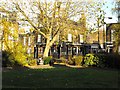
4
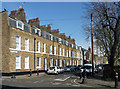
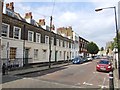
9-16 York Square
The north side of this modest but dignified square of c1825. The area was developed by the Mercers' Company. The architect was George Smith. Two-storey houses with mansard roofs. Grade II listed.
Acquired and renovated by the Greater London Council in 1973.
Image: © Stephen Richards
Taken: 12 Mar 2012
0.03 miles
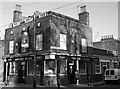
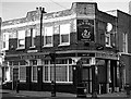
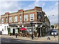
7
Queen's Head, E14
Viewed from the garden in York Square is the Queen's Head on the corner of Chaseley Street and Flamborough Street. Not to be confused with a similarly named pub in a popular BBC soap opera.
Young's Brewery's comment: http://www.youngs.co.uk/pub-detail.asp?PubID=321
Image: © Peter Thwaite
Taken: 11 Nov 2008
0.04 miles
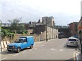
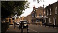
10
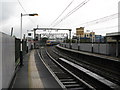
Limehouse station
Limehouse was a station on London's second-oldest railway, the London and Blackwall of 1840, although that station was situated almost half a mile further east, whereas the station near the above point was then called Stepney. The tracks shown in this photograph did not open until 1849 and eventually became part of the London, Tilbury and Southend railway. In this photograph, a 'c2c' train has just departed towards Fenchurch Street. Further to the left is the original London & Blackwall route, now occupied by the Docklands Light Railway.
Image: © Dr Neil Clifton
Taken: 24 Sep 2008
0.04 miles