IMAGES TAKEN NEAR TO
Basin Approach, LONDON, E14 7JN
Introduction
This page details the photographs taken nearby to Basin Approach, E14 7JN by members of the Geograph project.
The Geograph project started in 2005 with the aim of publishing, organising and preserving representative images for every square kilometre of Great Britain, Ireland and the Isle of Man.

There are currently over 7.5m images from over14,400 individuals and you can help contribute to the project by visiting https://www.geograph.org.uk
Image Map
Images are licensed for reuse under creativecommons.org/licenses/by-sa/2.0
Notes
- Clicking on the map will re-center to the selected point.
- The higher the marker number, the further away the image location is from the centre of the postcode.
Image Listing (473 Images Found)
Images are licensed for reuse under creativecommons.org/licenses/by-sa/2.0
Image
Details
Distance
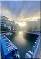
2
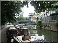
Limehouse Basin (7)
The Thames sailing barge Cabby in Limehouse Basin.
Image: © The Carlisle Kid
Taken: 10 Apr 2014
0.01 miles
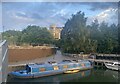
3
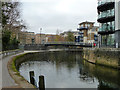
A junction of watery walks
At the sharp corner that now takes the Limehouse Cut into the Regents Canal Dock alias Limehouse Basin. Formerly this cut connected directly via a lock to the Thames, routing to the right of the view. Before this again, there was a connection to the basin, but it was later eliminated.
Image: © Robin Webster
Taken: 11 Dec 2010
0.02 miles
5
Limehouse Cut
Towards the southern end, which now joins the Regents Canal Dock (Limehouse Basin).
Image: © Robin Webster
Taken: 11 Dec 2010
0.02 miles
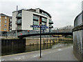
6
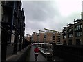
Flats on Limehouse Basin, viewed from the Limehouse Cut
Looking north-northwest.
Image: © Robert Lamb
Taken: 24 Apr 2012
0.02 miles
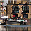
7
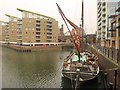
Cabby at Limehouse
Rochester-registered Cabby was, allegedly, the last wooden sailing barge ever built and was launched at Strood in 1928. She is now available for hire. The ship-shaped flats on the left, of which only part of the nearest is in square, are built above the Limehouse Link road tunnel.
Image: © Derek Harper
Taken: 1 Feb 2011
0.03 miles
8
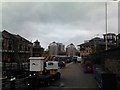
View of flats on the Limehouse Basin from Victoria Wharf
Looking north-northeast, with Northey Street (how appropriate) to the right.
Image: © Robert Lamb
Taken: 24 Apr 2012
0.03 miles
10
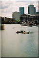
Cormorants in Limehouse Basin
View east across Limehouse Basin showing nesting cormorants. Straight ahead is the modern connection to Limehouse Cut, which formerly connected directly to the Thames. Behind is Canary Wharf
Image: © Pierre Terre
Taken: 7 May 2005
0.03 miles