IMAGES TAKEN NEAR TO
Newell Street, LONDON, E14 7HR
Introduction
This page details the photographs taken nearby to Newell Street, E14 7HR by members of the Geograph project.
The Geograph project started in 2005 with the aim of publishing, organising and preserving representative images for every square kilometre of Great Britain, Ireland and the Isle of Man.

There are currently over 7.5m images from over14,400 individuals and you can help contribute to the project by visiting https://www.geograph.org.uk
Image Map (Loading...)


Getting Data...Please wait
Leaflet Map data © OpenStreetMap
Images are licensed for reuse under creativecommons.org/licenses/by-sa/2.0
Notes
- Clicking on the map will re-center to the selected point.
- The higher the marker number, the further away the image location is from the centre of the postcode.
Image Listing (388 Images Found)
Images are licensed for reuse under creativecommons.org/licenses/by-sa/2.0
Image
Details
Distance
1
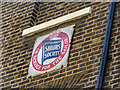
Plaque, British and Foreign Sailors' Society, Newell Street, Limehouse, London
This building is close to St Anne's Church.
Image: © Christine Matthews
Taken: 21 Aug 2013
0.00 miles
2
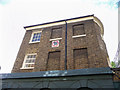
British and Foreign Sailors' Society, Newell Street, Limehouse, London
This building is close to St Anne's Church. See Image] for close-up of plaque.
Image: © Christine Matthews
Taken: 21 Aug 2013
0.00 miles
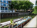
3
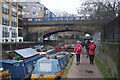
Limehouse Cut
Walkers on the towpath of the oldest canal in London - https://canalrivertrust.org.uk/enjoy-the-waterways/canal-and-river-network/limehouse-cut
Image: © Jim Osley
Taken: 29 Jan 2020
0.01 miles
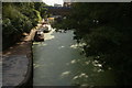
4
London : Tower Hamlets - Limehouse Cut
Looking down to the water from Commercial Road.
Image: © Lewis Clarke
Taken: 22 Feb 2023
0.01 miles
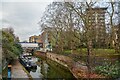
5
Limehouse Cut, Limehouse, London
Looking along the Limehouse Cut away from the railway bridge.
Image: © Christine Matthews
Taken: 21 Aug 2013
0.01 miles
6
View of the Limehouse Cut towards Limehouse from Commercial Road
Looking southwest.
Image: © Robert Lamb
Taken: 5 Sep 2020
0.01 miles
7
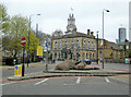
Limehouse Town Hall
On Commercial Road (A13), with the tower of Limehouse Church, St Anne's, beyond. The town hall is a grade II listed building of 1879.
Image: © Robin Webster
Taken: 6 Apr 2019
0.02 miles
8
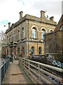
Limehouse Town Hall (former)
Grade II listed - description at this https://historicengland.org.uk/listing/the-list/list-entry/1240047?section=official-list-entry. Foundation stone declares that the building was designed by the architects A&C Harston. A comprehensive history of the building may be found at this https://www.limehousetownhall.co.uk/LTHCTExhibition2.0.pdf.
Image: © Jim Osley
Taken: 16 Feb 2024
0.02 miles
9

Britannia Bridge, Limehouse
Looking south, where Commercial Road crosses Limehouse Cut
Image: © Dr Neil Clifton
Taken: 3 Sep 2008
0.03 miles
10
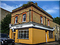
Trade & Care, Newell Street, Limehouse, London
This building is close to St Anne's Church.
Image: © Christine Matthews
Taken: 21 Aug 2013
0.03 miles