IMAGES TAKEN NEAR TO
Rolling Mills Mews, LONDON, E14 7FQ
Introduction
This page details the photographs taken nearby to Rolling Mills Mews, E14 7FQ by members of the Geograph project.
The Geograph project started in 2005 with the aim of publishing, organising and preserving representative images for every square kilometre of Great Britain, Ireland and the Isle of Man.

There are currently over 7.5m images from over14,400 individuals and you can help contribute to the project by visiting https://www.geograph.org.uk
Image Map
Images are licensed for reuse under creativecommons.org/licenses/by-sa/2.0
Notes
- Clicking on the map will re-center to the selected point.
- The higher the marker number, the further away the image location is from the centre of the postcode.
Image Listing (490 Images Found)
Images are licensed for reuse under creativecommons.org/licenses/by-sa/2.0
Image
Details
Distance
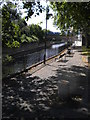
2
Docklands Light Railway towards Westferry
Image: © Oast House Archive
Taken: 26 Jun 2014
0.01 miles
3
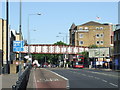
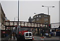
Commercial Road, Limehouse
Commercial Road in Limehouse, East London. This road, which is designated as the A13, used to be the main road heading eastwards out of London towards Southend, but much of the traffic now bypasses this area using new tunnels on the A1203.
The railway bridge in the background is disused.
Image: © Malc McDonald
Taken: 3 Jun 2011
0.02 miles
4
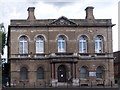
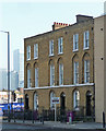
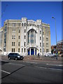
Former town hall, Limehouse
Grade II listed building, described at this http://list.english-heritage.org.uk/resultsingle.aspx?uid=1240047. Built to the designs of architects Arthur and Christopher Harston.
Image: © Jim Osley
Taken: 13 Aug 2014
0.02 miles
6
604-608 Commercial Road
The remains of an early C19th terrace. Arched ground-floor windows and first-floor windows set in blank arches. Grade II listed.
In the distance are the towers of Canary Wharf.
Image: © Stephen Richards
Taken: 12 Mar 2012
0.03 miles
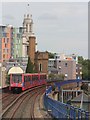
7
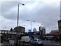
View of Canary Wharf from Commercial Road
Looking south-southeast. The viaduct looks to be another remnant of the London and Blackwall Railway. A DLR train can be seen rounding the curve into Limehouse station in the background.
Image: © Robert Lamb
Taken: 24 Apr 2012
0.03 miles
8
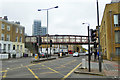
Disused railway bridge over Commercial Road
A grade II listed structure of the 1870s. This carried the Limehouse Curve, this enabled Great Eastern Railway goods trains to run straight through to the docks without reversal west of the existing Limehouse Junction.
Image: © Robin Webster
Taken: 6 Apr 2019
0.03 miles
9
The Mission, Commercial Road E14
At the junction of Salmon Lane
Image: © Robin Sones
Taken: 24 Aug 2010
0.03 miles
10
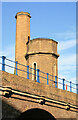
Hydraulic accumulator tower and chimney, Limehouse
This hydraulic pumping station was housed in an arch of the viaduct with the chimney and accumulator tower alongside. It provided power to cranes, capstans and hoists in Limehouse Basin or as it was then the Regent's Canal Dock. Dating from 1869, it is the earliest surviving example in London. A staircase has been inserted inside the weight case of the accumulator and there is a roof top viewing platform that is open on London Open House days (is somebody going to get some shots for the site?).
Image: © Chris Allen
Taken: 21 Aug 2011
0.03 miles