IMAGES TAKEN NEAR TO
Dod Street, LONDON, E14 7ET
Introduction
This page details the photographs taken nearby to Dod Street, E14 7ET by members of the Geograph project.
The Geograph project started in 2005 with the aim of publishing, organising and preserving representative images for every square kilometre of Great Britain, Ireland and the Isle of Man.

There are currently over 7.5m images from over14,400 individuals and you can help contribute to the project by visiting https://www.geograph.org.uk
Image Map (Loading...)


Getting Data...Please wait
Leaflet Map data © OpenStreetMap
Images are licensed for reuse under creativecommons.org/licenses/by-sa/2.0
Notes
- Clicking on the map will re-center to the selected point.
- The higher the marker number, the further away the image location is from the centre of the postcode.
Image Listing (66 Images Found)
Images are licensed for reuse under creativecommons.org/licenses/by-sa/2.0
Image
Details
Distance
1
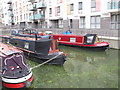
Abbotts Wharf Mooring with Peace of Pearce and Navigator
The flats around the small Limehouse Cut basin have the address "Abbotts Wharf", just off Stainsby Place and Stainsby Road. The mooring is for residents only - narrowboat Peace of Pearce is far right, Navigator is far left.
Image: © David Hawgood
Taken: 10 Oct 2015
0.03 miles
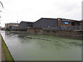
2
Abbott's Wharf, Limehouse Cut
The name is old, but the inlet is not, it was made when the residential redevelopment took place. It appears from old maps that the industry on this side of the canal moved goods across the towpath.
Image: © Robin Webster
Taken: 11 Dec 2010
0.04 miles
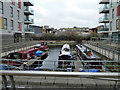
3

Abbotts Wharf Mooring with narrowboat Navigator
Navigator is on the right. The Limehouse Cut towpath diverts around this small basin.
Image: © David Hawgood
Taken: 10 Oct 2015
0.04 miles
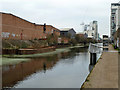
6
Thomas Road Industrial Estate, by Limehouse Cut
Image: © David Hawgood
Taken: 10 Oct 2015
0.07 miles
7

Old Boundary Marker on school building, Pelling Street, Poplar
Parish Boundary Marker by the UC road, in parish of Poplar (Tower Hamlets District), Pelling Street E14, on old school building, high up on wall, West side of road. Adjacent to boundary marker: MX_SAM03pb https://www.geograph.org.uk/photo/6056197
Inscription reads:-
A.S
P
Surveyed
Milestone Society National ID: MX_ASP03pb
Image: © Milestone Society
Taken: Unknown
0.08 miles
8

Old Boundary Marker by Pelling Street, Poplar parish
Parish Boundary Marker by the UC road, in parish of Poplar (Tower Hamlets District), Pelling Street E14, on old school building high up on wall. To the right of: MX_ASP03pb https://www.geograph.org.uk/photo/6094754
Inscription reads:-
Sᵀ
A | M
Churchwardens | 1884
W B HOPSON| 1890
C T SMITH |
Overseers |
C.CAPP |
H C BRAINE |
J WALKER | 48
Surveyed
Milestone Society National ID: MX_SAM03pb
Image: © Milestone Society
Taken: Unknown
0.08 miles
9
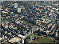
Bow Common from the air
Limehouse Cut can be seen to the lower right.
Image: © Thomas Nugent
Taken: 26 Aug 2019
0.08 miles