IMAGES TAKEN NEAR TO
Dod Street, LONDON, E14 7ED
Introduction
This page details the photographs taken nearby to Dod Street, E14 7ED by members of the Geograph project.
The Geograph project started in 2005 with the aim of publishing, organising and preserving representative images for every square kilometre of Great Britain, Ireland and the Isle of Man.

There are currently over 7.5m images from over14,400 individuals and you can help contribute to the project by visiting https://www.geograph.org.uk
Image Map
Images are licensed for reuse under creativecommons.org/licenses/by-sa/2.0
Notes
- Clicking on the map will re-center to the selected point.
- The higher the marker number, the further away the image location is from the centre of the postcode.
Image Listing (184 Images Found)
Images are licensed for reuse under creativecommons.org/licenses/by-sa/2.0
Image
Details
Distance
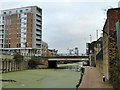
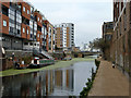
3
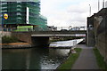
Burdett Road bridge over Limehouse Cut
Looking north-east.
Image: © Dr Neil Clifton
Taken: 3 Sep 2008
0.06 miles
5
Burdett Road bridge, Limehouse Cut
The A1205 crosses.
Image: © Robin Webster
Taken: 11 Dec 2010
0.06 miles
6
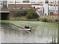
Canoe by Burdett Road bridge, Limehouse Cut
Image: © David Hawgood
Taken: 10 Oct 2015
0.07 miles
7
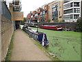
Tramps Retreat, narrowboat on the Limehouse Cut
Approaching under the scaffolding is a group of Boy Scouts, picking up litter.
Image: © David Hawgood
Taken: 10 Oct 2015
0.07 miles
8
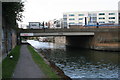
Burdett Road bridge over Limehouse Cut
Looking southwest.
Image: © Dr Neil Clifton
Taken: 3 Sep 2008
0.07 miles
9
Limehouse Cut
Looking north towards the A1205 Burdett Road bridge.
Image: © Robin Webster
Taken: 11 Dec 2010
0.07 miles
10

Old Boundary Marker by Farrance Street, Poplar Parish
Parish Boundary Marker by the UC road, in parish of Poplar (Tower Hamlets District), Farrance Street E14, old school building, body height behind railings. To the left of Boundary Marker: MX_SAM01pb Image
Surveyed
Milestone Society National ID: MX_ASP01pb.
Image: © Milestone Society
Taken: Unknown
0.08 miles