IMAGES TAKEN NEAR TO
Chrisp Street, LONDON, E14 6RS
Introduction
This page details the photographs taken nearby to Chrisp Street, E14 6RS by members of the Geograph project.
The Geograph project started in 2005 with the aim of publishing, organising and preserving representative images for every square kilometre of Great Britain, Ireland and the Isle of Man.

There are currently over 7.5m images from over14,400 individuals and you can help contribute to the project by visiting https://www.geograph.org.uk
Image Map
Images are licensed for reuse under creativecommons.org/licenses/by-sa/2.0
Notes
- Clicking on the map will re-center to the selected point.
- The higher the marker number, the further away the image location is from the centre of the postcode.
Image Listing (119 Images Found)
Images are licensed for reuse under creativecommons.org/licenses/by-sa/2.0
Image
Details
Distance
1
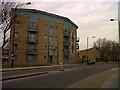
Contemporary housing on Morris Road
A four-storey apartment block on the west side of Morris Road.
Image: © Stephen Craven
Taken: 6 Mar 2013
0.01 miles
2
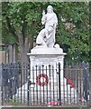
World War 1 memorial, Bromley-by-Bow
No. 18049 on the War Memorials Archive, listed at this http://www.ukniwm.org.uk/server/show/conMemorial.18049/fromUkniwmSearch/1.
Image: © Jim Osley
Taken: 13 Aug 2014
0.04 miles
3
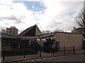
St. Saviour's Primary School, Bow
On Chrisp Street.
Image: © David Anstiss
Taken: 15 Feb 2012
0.04 miles
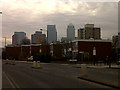
4

View of Parkview Apartments, Chrisp Street from Willis Street
Looking north-northwest from the bridge over the DLR.
Image: © Robert Lamb
Taken: 8 Sep 2013
0.05 miles
5
Low-rise housing on Chrisp Street
Two-storey houses on the west side of Chris Street, with similar housing facing Carmen Street behind. Godalming Road runs off to the right of the photo. The towers of the Canary Wharf development in the background.
Image: © Stephen Craven
Taken: 6 Mar 2013
0.05 miles
6
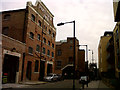
Fawe Street
This short street, a dead-end apart from a footbridge over the DLR at its east end, perfectly illustrates the changing face of East London. On the left, a former factory building, still in industrial use as a foundry Image and on the right, contemporary apartments.
Image: © Stephen Craven
Taken: 6 Mar 2013
0.06 miles
7
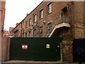
Workshop entrance in Fawe Street
The green metal gates are the discreet entrance to a workshop whose owner has good reasons for not advertising it. For context see Image
Image: © Stephen Craven
Taken: 6 Mar 2013
0.07 miles
8
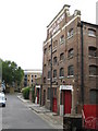
Poplar: Former Spratts' Pet Food factory (3)
This is the Fawe Street frontage of the former factory on its south side. Spratt's Patent Limited was the formal name of the company.
Image: © Nigel Cox
Taken: 19 Aug 2008
0.07 miles
9
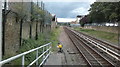
View of the DLR tracks heading towards Devons Road station
Looking north-northwest from Langdon Park station.
Image: © Robert Lamb
Taken: 8 Sep 2013
0.07 miles
10
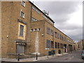
Empty warehouse, Bow
Large empty brick warehouse on the junction of Chrisp Street (on the left) and Barchester Street (on the right).
Image: © David Anstiss
Taken: 15 Feb 2012
0.09 miles