IMAGES TAKEN NEAR TO
Follett Street, LONDON, E14 6LG
Introduction
This page details the photographs taken nearby to Follett Street, E14 6LG by members of the Geograph project.
The Geograph project started in 2005 with the aim of publishing, organising and preserving representative images for every square kilometre of Great Britain, Ireland and the Isle of Man.

There are currently over 7.5m images from over14,400 individuals and you can help contribute to the project by visiting https://www.geograph.org.uk
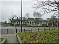
Image Map
Images are licensed for reuse under creativecommons.org/licenses/by-sa/2.0
Notes
- Clicking on the map will re-center to the selected point.
- The higher the marker number, the further away the image location is from the centre of the postcode.
Image Listing (222 Images Found)
Images are licensed for reuse under creativecommons.org/licenses/by-sa/2.0
Image
Details
Distance
1
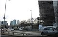
View of Canary Wharf from Poplar
I was one of the first visitors to Canary Wharf in 1981, delivering a parcel when it was a Portakabin.
Image: © David Howard
Taken: 21 Mar 2020
0.02 miles
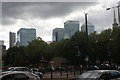
2
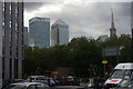
View of Canary Wharf and All Saints Church from Commercial Road
Looking south-southwest.
Image: © Robert Lamb
Taken: 5 Sep 2020
0.03 miles
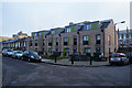
3
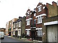
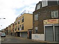
Poplar: Follett Street, E14 (2)
Many of the buildings that existed in Poplar at the start of the Second World War were either damaged during the Blitz, or else had to be demolished after the war in order to undertake the essential complete redevelopment of the area. Just occasionally some pockets of pre-war buildings remain, cheek by jowl, with more modern buildings, as here in Follett Street.
Firstly on the right is a building dating from 1899. The cross in the date tablet suggests that this is ecclesiastical in origin, and probably associated with Image which is opposite. Secondly and beyond it is one of the few surviving ordinary Victorian residential properties, that must have been typical of a lot in the area. Beyond that the street reverts to one of the usual tedious and anonymous small blocks of flats.
Image: © Nigel Cox
Taken: 19 Aug 2008
0.03 miles
5
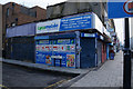
Poplar Convenience Store, East India Dock Road
Image: © Ian S
Taken: 1 Mar 2014
0.03 miles
6
Indigo Mews, seen from East India Dock Road
Access is via nearby Ashton Street.
Image: © Danny P Robinson
Taken: 11 Jul 2009
0.04 miles
7
View of Canary Wharf from Commercial Road
Looking south-southwest.
Image: © Robert Lamb
Taken: 5 Sep 2020
0.04 miles
9
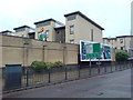
Derelict school, Poplar
The site is now redeveloped. The school opened in 1914 as an infant school and closed in 1983 after a change of name, it was last known as St Matthias Church of England School.
Image: © Robin Webster
Taken: 29 Jan 2011
0.04 miles
10
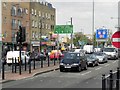
Poplar: Follett Street, E14 (1)
The changing demographics of the East End are visible here. High up on the building on the right is an advert that I can't quite completely decipher, but seems to be advising that the family grocers previously resident there used to have the largest sale of a certain brand of soap in the world. Their shop is now Hin Cheong's Chinese takeaway, while the building with the buff bricks is in use as a Somali community centre.
Image: © Nigel Cox
Taken: 19 Aug 2008
0.05 miles