IMAGES TAKEN NEAR TO
Hind Grove, LONDON, E14 6HT
Introduction
This page details the photographs taken nearby to Hind Grove, E14 6HT by members of the Geograph project.
The Geograph project started in 2005 with the aim of publishing, organising and preserving representative images for every square kilometre of Great Britain, Ireland and the Isle of Man.

There are currently over 7.5m images from over14,400 individuals and you can help contribute to the project by visiting https://www.geograph.org.uk
Image Map
Images are licensed for reuse under creativecommons.org/licenses/by-sa/2.0
Notes
- Clicking on the map will re-center to the selected point.
- The higher the marker number, the further away the image location is from the centre of the postcode.
Image Listing (82 Images Found)
Images are licensed for reuse under creativecommons.org/licenses/by-sa/2.0
Image
Details
Distance
1
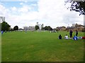
Limehouse, Bartlett Park
Tower Hamlets park with football pitches and playground.
Image: © Mike Faherty
Taken: 26 Aug 2012
0.02 miles
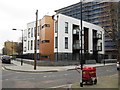
3
Saracen Street, Poplar
The dwellings on Saracen Street form the north site of the Lansbury Estate. They were built 1951-1952 to the designs of architects Norman and Dawbarn. For a comprehensive account of the Lansbury Estate and the Festival of Britain (1951) see this http://www.british-history.ac.uk/report.aspx?compid=46490. The shop on the left of the image was originally a public house, "The Chimes" built to the designs of architects Stewart & Hendry.
Image: © Jim Osley
Taken: 13 Aug 2014
0.06 miles
4
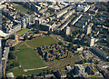
Church of St Saviour from the air
A derelict church surrounded by a cluster of houses in an area of parkland. See Image for more information.
Image: © Thomas Nugent
Taken: 26 Aug 2019
0.09 miles
5
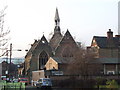
St. Saviour, Northumbria Street, Poplar
Image: © Chris Whippet
Taken: 8 Jan 2009
0.10 miles
6

Old Boundary Marker by Pelling Street, Poplar parish
Parish Boundary Marker by the UC road, in parish of Poplar (Tower Hamlets District), Pelling Street E14, on old school building high up on wall. To the right of: MX_ASP03pb https://www.geograph.org.uk/photo/6094754
Inscription reads:-
Sᵀ
A | M
Churchwardens | 1884
W B HOPSON| 1890
C T SMITH |
Overseers |
C.CAPP |
H C BRAINE |
J WALKER | 48
Surveyed
Milestone Society National ID: MX_SAM03pb
Image: © Milestone Society
Taken: Unknown
0.10 miles
7

Old Boundary Marker on school building, Pelling Street, Poplar
Parish Boundary Marker by the UC road, in parish of Poplar (Tower Hamlets District), Pelling Street E14, on old school building, high up on wall, West side of road. Adjacent to boundary marker: MX_SAM03pb https://www.geograph.org.uk/photo/6056197
Inscription reads:-
A.S
P
Surveyed
Milestone Society National ID: MX_ASP03pb
Image: © Milestone Society
Taken: Unknown
0.10 miles
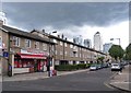
8
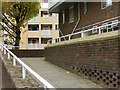
Canton Street, Poplar
The western end of Canton Street is line with blocks of flats, all built in the post-war era. This shows a walkway leading up from the street giving access to the block on the right. Canton Street is one of several in this immediate area with Chinese names.
Image: © Stephen McKay
Taken: 23 Oct 2015
0.10 miles
9

Old Boundary Marker by Farrance Street, Poplar parish
Parish Boundary Marker by the UC road, in parish of Poplar (Tower Hamlets District), Farrance Street E14, on old school building, low down on wall below ground floor window. Adjacent to Boundary Marker: MX_SAM02pb Image
Surveyed
Milestone Society National ID: MX_ASP02pb
Image: © Milestone Society
Taken: Unknown
0.11 miles
10

Old Boundary Marker by Farrance Street, Poplar parish
Parish Boundary Marker by the UC road, in parish of Poplar (Tower Hamlets District), Farrance Street E14, on old school building low down on wall, below ground floor window. Adjacent to Boundary Marker: MX_ASP02pb Image
Surveyed
Milestone Society National ID: MX_SAM02pb
Image: © Milestone Society
Taken: Unknown
0.11 miles