IMAGES TAKEN NEAR TO
New Festival Avenue, LONDON, E14 6FT
Introduction
This page details the photographs taken nearby to New Festival Avenue, E14 6FT by members of the Geograph project.
The Geograph project started in 2005 with the aim of publishing, organising and preserving representative images for every square kilometre of Great Britain, Ireland and the Isle of Man.

There are currently over 7.5m images from over14,400 individuals and you can help contribute to the project by visiting https://www.geograph.org.uk
Image Map
Images are licensed for reuse under creativecommons.org/licenses/by-sa/2.0
Notes
- Clicking on the map will re-center to the selected point.
- The higher the marker number, the further away the image location is from the centre of the postcode.
Image Listing (84 Images Found)
Images are licensed for reuse under creativecommons.org/licenses/by-sa/2.0
Image
Details
Distance
1
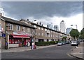
Saracen Street, Poplar
The dwellings on Saracen Street form the north site of the Lansbury Estate. They were built 1951-1952 to the designs of architects Norman and Dawbarn. For a comprehensive account of the Lansbury Estate and the Festival of Britain (1951) see this http://www.british-history.ac.uk/report.aspx?compid=46490. The shop on the left of the image was originally a public house, "The Chimes" built to the designs of architects Stewart & Hendry.
Image: © Jim Osley
Taken: 13 Aug 2014
0.05 miles
2
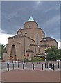
Church of St Mary and St Joseph, Poplar
Built in the 1950s to the designs of architect Adrian Gilbert Scott (1882-1963).
Image: © Jim Osley
Taken: 13 Aug 2014
0.06 miles
3
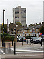
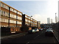
Grundy Street, Poplar
Seen from the junction with North Street. A combination of enemy action and slum clearance schemes means that most of Poplar has a post-war appearance. In this view there are various housing styles and a few remaining older buildings.
Image: © Stephen McKay
Taken: 23 Oct 2015
0.09 miles
4
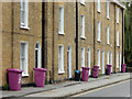
Upper North Street, Poplar
An attractive terrace of grade II listed Georgian town houses, a happy survival in an area comprehensively redeveloped since the Second World War. The effect is spoiled somewhat by the mauve wheely bins.
Image: © Stephen McKay
Taken: 23 Oct 2015
0.10 miles
5
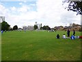
Limehouse, Bartlett Park
Tower Hamlets park with football pitches and playground.
Image: © Mike Faherty
Taken: 26 Aug 2012
0.10 miles
6
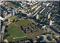
Church of St Saviour from the air
A derelict church surrounded by a cluster of houses in an area of parkland. See Image for more information.
Image: © Thomas Nugent
Taken: 26 Aug 2019
0.10 miles
7
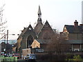
St. Saviour, Northumbria Street, Poplar
Image: © Chris Whippet
Taken: 8 Jan 2009
0.12 miles
8
Canton Street, Poplar
The western end of Canton Street is line with blocks of flats, all built in the post-war era. This shows a walkway leading up from the street giving access to the block on the right. Canton Street is one of several in this immediate area with Chinese names.
Image: © Stephen McKay
Taken: 23 Oct 2015
0.12 miles
10
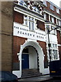
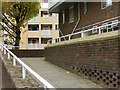
Seamen's Rest, original entrance
This is the Jeremiah Street entrance of Queen Victoria Seamen's Rest opened in 1902. See http://www.portcities.org.uk/london/server/show/ConNarrative.141/chapterId/2941/The-welfare-of-seamen.html for contemporary photos.
Earlier there was a small mission, run by the Wesletyan Methodist church, consisting of a plainly furnished reading room and rest room with a third room available for daily Bible and Prayer meetings. An elementary nautical school ran three mornings a week and services were held on Monday and Friday evenings.
Prior to that on this spot stood a tavern appositely named The Magnet - a considerable attraction, no doubt, to the recently-paid-off sailors who thronged this area. The Methodists had it closed down and took over the site.
Image: © Natasha Ceridwen de Chroustchoff
Taken: 26 Jun 2008
0.12 miles