IMAGES TAKEN NEAR TO
Market Way, LONDON, E14 6AH
Introduction
This page details the photographs taken nearby to Market Way, E14 6AH by members of the Geograph project.
The Geograph project started in 2005 with the aim of publishing, organising and preserving representative images for every square kilometre of Great Britain, Ireland and the Isle of Man.

There are currently over 7.5m images from over14,400 individuals and you can help contribute to the project by visiting https://www.geograph.org.uk
Image Map
Images are licensed for reuse under creativecommons.org/licenses/by-sa/2.0
Notes
- Clicking on the map will re-center to the selected point.
- The higher the marker number, the further away the image location is from the centre of the postcode.
Image Listing (208 Images Found)
Images are licensed for reuse under creativecommons.org/licenses/by-sa/2.0
Image
Details
Distance
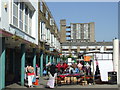
1
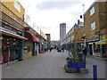
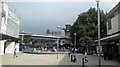
Poplar, shopping centre
Looking towards Chrisp Street Market.
Image: © Mike Faherty
Taken: 30 Nov 2013
0.02 miles
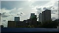
2

View of Canary Wharf, flats off Chrisp Street and Kerbery Street and the "Chrisp Street Clocktopus" from Willis Street #2
Looking across the Chrisp Street car park, looking south-southwest.
Image: © Robert Lamb
Taken: 8 Sep 2013
0.04 miles
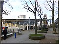
3
Chrisp Street Market, Poplar
The centrepiece of the 1950s Lansbury Estate is Chrisp Street Market, built as part of the Festival of Britain. The first pedestrianised shopping area in the UK, built to the designs of architect Frederick Gibberd.
Image: © Jim Osley
Taken: 13 Aug 2014
0.04 miles
4
Chrisp Street, fifties architecture
The 1951 redevelopment of Chrisp Street involved a then-innovative combination of shopping precinct and residential accommodation: so-called Living Architecture. This was all part of the Lansbury Estate experiment in social housing that paved the way for the New Town developments, see http://www.guardian.co.uk/society/2001/jul/11/communities.urbandesign
(The sign on the lamp post warns that cars parked illegally may be clamped or towed away.)
Image: © Natasha Ceridwen de Chroustchoff
Taken: 26 Jun 2008
0.04 miles
5
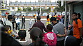
View of the parade for the Chrisp Street Festival waiting for the traffic on Chrisp Street to be stopped
Looking north-northeast.
Image: © Robert Lamb
Taken: 8 Sep 2013
0.04 miles
6
Looking into Chrisp Street Market from the pedestrianised area leading to Kerbery Street
Looking east. Balfron Tower near the Blackwall Tunnel can be seen above and behind the market, and the clock tower (decorated with what look like inflatable tentacles) can be seen on the right.
Image: © Robert Lamb
Taken: 8 Sep 2013
0.05 miles
7
View of Canary Wharf, flats off Chrisp Street and Kerbery Street and the "Chrisp Street Clocktopus" from Willis Street
Looking south-southwest. The name "Chrisp Street Clocktopus" is of my own coinage - I couldn't think of a better thing to call it whilst it was decorated with those inflatable tentacles!
Image: © Robert Lamb
Taken: 8 Sep 2013
0.05 miles
8
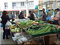
Tropical veg at Chrisp Street market
Although the area has long been ethnically diverse, the old Cockney barrow boys would not have been able to offer this range of tropical greengrocery.
Nearest the camera here are yardlong beans (more like 18 inches in fact) which are popular in China and SE Asia. Behind are various types of gourds and snow peas.
Image: © Natasha Ceridwen de Chroustchoff
Taken: 26 Jun 2008
0.06 miles
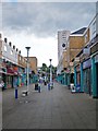
9
Poplar, Chrisp Street Market
Covered market in Market Square. http://www.chrispstreet.org.uk/history-and-heritage/
Image: © Mike Faherty
Taken: 30 Nov 2013
0.06 miles
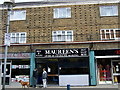
10
Chrisp Street Market
The north side of the market square, Chrisp Street Market.
Image: © Malc McDonald
Taken: 17 Apr 2010
0.06 miles