IMAGES TAKEN NEAR TO
Boardwalk Place, LONDON, E14 5SG
Introduction
This page details the photographs taken nearby to Boardwalk Place, E14 5SG by members of the Geograph project.
The Geograph project started in 2005 with the aim of publishing, organising and preserving representative images for every square kilometre of Great Britain, Ireland and the Isle of Man.

There are currently over 7.5m images from over14,400 individuals and you can help contribute to the project by visiting https://www.geograph.org.uk
Image Map
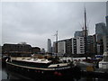
Images are licensed for reuse under creativecommons.org/licenses/by-sa/2.0
Notes
- Clicking on the map will re-center to the selected point.
- The higher the marker number, the further away the image location is from the centre of the postcode.
Image Listing (323 Images Found)
Images are licensed for reuse under creativecommons.org/licenses/by-sa/2.0
Image
Details
Distance
1
View of a towerblock in Canary Wharf, The Gentry and the Citibank Building from Poplar Dock
Looking west.
Image: © Robert Lamb
Taken: 24 Nov 2012
0.02 miles
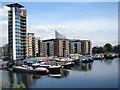
2
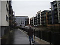
View of apartments off Poplar Dock
Looking north-northwest.
Image: © Robert Lamb
Taken: 24 Nov 2012
0.02 miles
3
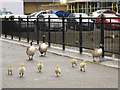
Inquisitive goslings
These six goslings, with three adult birds following, came running towards us. When they got close the parents started hissing at us.
Image: © Stephen Craven
Taken: 23 May 2015
0.02 miles
4
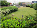
Lawn with geese
A small area of maintained grass by Poplar Dock. The two geese here seemed to be playing a game of hide-and-seek with their young: the goslings seen in Image had run into the bushes in the foreground, and the parents knew that, but were still looking round as if to say "where are they hiding?".
Image: © Stephen Craven
Taken: 23 May 2015
0.02 miles
5
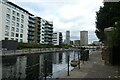
Towards Poplar Dock
Looking along the connecting waterway between Blackwall Basin and Poplar Dock.
Image: © DS Pugh
Taken: 2 Aug 2022
0.03 miles
6
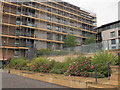
Dockland garden
A small but colourfully planted garden at the north end of Blackwall Basin.
Image: © Stephen Craven
Taken: 23 May 2015
0.04 miles
7
Boats in Poplar Dock
These two are Sans Egal and Wylam.
Image: © Stephen Craven
Taken: 23 May 2015
0.04 miles
8
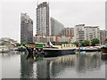
Poplar Dock Marina
Poplar Dock was London's first railway dock when it opened in 1851. The site was first developed by the West India Dock Company in 1827–8 as reservoirs. They were converted into a timber pond in 1844 and in 1850–1 into a railway dock, following the transfer of the land to the East and West India Docks & Birmingham Junction Railway Company (later the North London Railway Company). The dock, used for coal and export goods traffic, was extended to the west in 1875–7 to provide depots for other railway companies.
Operations at Poplar Dock ceased in 1981, following closure of the India and Millwall Docks, and British Rail sold the site to the London Docklands Development Corporation in 1982–3. A full history can be seen at www.british-history.ac.uk/survey-london/vols43-4/pp336-341
In this photograph, the O2 Arena can just be glimpsed through the gap in the centre.
Image: © Marathon
Taken: 1 Feb 2023
0.05 miles
9
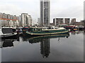
View of Blackwall Basin Barges and Flats
Image: © Ian Paterson
Taken: 5 Jun 2008
0.05 miles
10
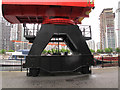
Crane at Poplar Dock (detail)
A sideways view of the base of the crane seen in Image
Image: © Stephen Craven
Taken: 23 May 2015
0.05 miles