IMAGES TAKEN NEAR TO
Wateridge Close, LONDON, E14 3SN
Introduction
This page details the photographs taken nearby to Wateridge Close, E14 3SN by members of the Geograph project.
The Geograph project started in 2005 with the aim of publishing, organising and preserving representative images for every square kilometre of Great Britain, Ireland and the Isle of Man.

There are currently over 7.5m images from over14,400 individuals and you can help contribute to the project by visiting https://www.geograph.org.uk
Image Map
Images are licensed for reuse under creativecommons.org/licenses/by-sa/2.0
Notes
- Clicking on the map will re-center to the selected point.
- The higher the marker number, the further away the image location is from the centre of the postcode.
Image Listing (134 Images Found)
Images are licensed for reuse under creativecommons.org/licenses/by-sa/2.0
Image
Details
Distance
5
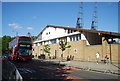
Docklands Sailing and Watersport Centre, Millwall Docks
Image: © N Chadwick
Taken: 31 Aug 2013
0.04 miles
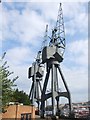
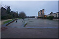
7
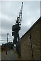
Old dock cranes at Millwall
Looking along a path along the north side of the dock.
Image: © DS Pugh
Taken: 2 Aug 2022
0.05 miles
8
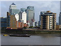
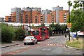
Flats Overlooking Limehouse Reach
London Docklands Redevelopment Area - modern flats in Millwall, a former district of warehouses. In the background are the tall office towers at Canary Wharf.
Image: © Colin Smith
Taken: 26 Sep 2010
0.05 miles
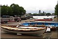
9
Turf Zone "Bellgate"
At Millwall Slipway, Isle of Dogs.
Image: © Ian S
Taken: 25 Dec 2022
0.05 miles
