IMAGES TAKEN NEAR TO
Da Gama Place, LONDON, E14 3QQ
Introduction
This page details the photographs taken nearby to Da Gama Place, E14 3QQ by members of the Geograph project.
The Geograph project started in 2005 with the aim of publishing, organising and preserving representative images for every square kilometre of Great Britain, Ireland and the Isle of Man.

There are currently over 7.5m images from over14,400 individuals and you can help contribute to the project by visiting https://www.geograph.org.uk
Image Map (Loading...)


Getting Data...Please wait
Leaflet Map data © OpenStreetMap
Images are licensed for reuse under creativecommons.org/licenses/by-sa/2.0
Notes
- Clicking on the map will re-center to the selected point.
- The higher the marker number, the further away the image location is from the centre of the postcode.
Image Listing (85 Images Found)
Images are licensed for reuse under creativecommons.org/licenses/by-sa/2.0
Image
Details
Distance
1
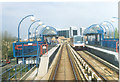
Isle of Dogs.
Approaching Mudchute Station on the D.L.R. That's an interesting name for a place, too. Isle of Dogs, I understand, came from the habit of earlier Royalty keeping their doge, especially hunting ones, in the area.
Image: © Ron Hann
Taken: Unknown
0.04 miles
2
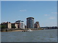
Riverside apartments on the Isle of Dogs
This is taken looking south-east down the Greenwich Reach of The Thames, which is bending back to the left round the tip of the Isle of Dogs (which is the land inside a big bend in the river, not an island).
Image: © David Hawgood
Taken: 18 Jun 2005
0.04 miles
3
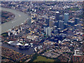
Canary Wharf from the air
Viewed from a Heathrow bound flight from Glasgow.
Image: © Thomas Nugent
Taken: 29 Aug 2011
0.04 miles
4
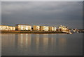
Looking across the river to Mast House Terrace Pier
Image: © N Chadwick
Taken: 17 Feb 2012
0.05 miles
5
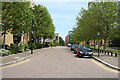
Isle of Dogs: Napier Avenue
Looking northeast
Image: © Dr Neil Clifton
Taken: 14 Jun 2012
0.05 miles
6
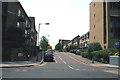
Isle of Dogs: Napier Avenue
Looking southwest from the junction with Westferry Road
Image: © Dr Neil Clifton
Taken: 14 Jun 2012
0.05 miles
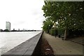
7
Isle of Dogs: Thames Path at Maritime Quay
The City skyscrapers are just visible in the distance.
Image: © Dr Neil Clifton
Taken: 14 Jun 2012
0.06 miles
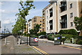
8
Maritime Quay in Millwall
The Thames Path runs along Maritime Quay.
Image: © Steve Daniels
Taken: 6 Sep 2013
0.06 miles
9
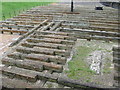
Launch site of SS Great Eastern, Isle of Dogs
These old timbers are what remains of the slipway from which was launched Brunel's ambitious but ill fated creation, the "SS Great Eastern". She was the first double skinned iron hulled ship to be built, the first to have steam powering paddle wheels as well as a propeller, and had six sail carrying masts as a back up. It was envisaged that with this combination she would sail round the world without refuelling. At a displacement of 32,000 tons, she was destined to be the largest ship for another forty one years.
Her huge size was to present enormous problems at the launch. Couldn't go stern first as she would have hit the far bank of the river. So a sideways launch was chosen. But again, her size and weight was too much and defeated the steam powered rams which were to push her broadside into the water. Only after the thirteenth attempt did they finally achieve success on the 31st of January 1858.
After fitting out, and on her maiden voyage her engine blew up, killing five stokers and one more who panicked and jumped overboard and was lost.
She did however complete several transatlantic crossings, mostly as a cable layer.
But alas, she proved to be far too costly to operate and was finally broken up in 1889. For a picture of the restraining chains used at the launch, see Image
Image: © Derek Voller
Taken: 14 Apr 2010
0.06 miles
10
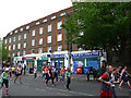
Row of shops on West Ferry Road
The shops (including West Quay post office) form the ground floor of one of the blocks of the London City Council's 1936 Westferry Estate, built to replace slums that had been flooded when the Thames overflowed its banks.
Photographed during the 2019 London Marathon.
Image: © Stephen Craven
Taken: 28 Apr 2019
0.06 miles