IMAGES TAKEN NEAR TO
Torres Square, LONDON, E14 3QN
Introduction
This page details the photographs taken nearby to Torres Square, E14 3QN by members of the Geograph project.
The Geograph project started in 2005 with the aim of publishing, organising and preserving representative images for every square kilometre of Great Britain, Ireland and the Isle of Man.

There are currently over 7.5m images from over14,400 individuals and you can help contribute to the project by visiting https://www.geograph.org.uk
Image Map
Images are licensed for reuse under creativecommons.org/licenses/by-sa/2.0
Notes
- Clicking on the map will re-center to the selected point.
- The higher the marker number, the further away the image location is from the centre of the postcode.
Image Listing (95 Images Found)
Images are licensed for reuse under creativecommons.org/licenses/by-sa/2.0
Image
Details
Distance
1
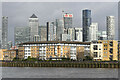
Isle of Dogs from Payne's Wharf
The tall buildings around Canary Wharf are more than a mile beyond the riverside apartments.
Image: © David Martin
Taken: 8 Jan 2023
0.04 miles
2
Looking across the river to Mast House Terrace Pier
Image: © N Chadwick
Taken: 17 Feb 2012
0.06 miles
3
Maritime Quay in Millwall
The Thames Path runs along Maritime Quay.
Image: © Steve Daniels
Taken: 6 Sep 2013
0.07 miles
4
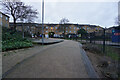
Turf Zone "Mudchute"
Next to Mudchute Skate Park off Westferry Road, Isle of Dogs.
Image: © Ian S
Taken: 25 Dec 2022
0.07 miles
5
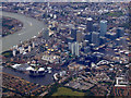
Canary Wharf from the air
Viewed from a Heathrow bound flight from Glasgow.
Image: © Thomas Nugent
Taken: 29 Aug 2011
0.08 miles
6
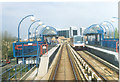
Isle of Dogs.
Approaching Mudchute Station on the D.L.R. That's an interesting name for a place, too. Isle of Dogs, I understand, came from the habit of earlier Royalty keeping their doge, especially hunting ones, in the area.
Image: © Ron Hann
Taken: Unknown
0.08 miles
7
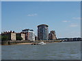
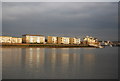
Riverside apartments on the Isle of Dogs
This is taken looking south-east down the Greenwich Reach of The Thames, which is bending back to the left round the tip of the Isle of Dogs (which is the land inside a big bend in the river, not an island).
Image: © David Hawgood
Taken: 18 Jun 2005
0.08 miles
8
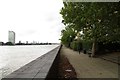
Isle of Dogs: Thames Path at Maritime Quay
The City skyscrapers are just visible in the distance.
Image: © Dr Neil Clifton
Taken: 14 Jun 2012
0.08 miles
9
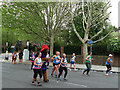
Paddington Bear runs the Marathon
This is the end of London least familiar to Paddington, who of course knows the west of the city much better.
Image: © Stephen Craven
Taken: 28 Apr 2019
0.08 miles
10
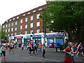
Row of shops on West Ferry Road
The shops (including West Quay post office) form the ground floor of one of the blocks of the London City Council's 1936 Westferry Estate, built to replace slums that had been flooded when the Thames overflowed its banks.
Photographed during the 2019 London Marathon.
Image: © Stephen Craven
Taken: 28 Apr 2019
0.08 miles