IMAGES TAKEN NEAR TO
East Ferry Road, LONDON, E14 3LH
Introduction
This page details the photographs taken nearby to East Ferry Road, E14 3LH by members of the Geograph project.
The Geograph project started in 2005 with the aim of publishing, organising and preserving representative images for every square kilometre of Great Britain, Ireland and the Isle of Man.

There are currently over 7.5m images from over14,400 individuals and you can help contribute to the project by visiting https://www.geograph.org.uk
Image Map
Images are licensed for reuse under creativecommons.org/licenses/by-sa/2.0
Notes
- Clicking on the map will re-center to the selected point.
- The higher the marker number, the further away the image location is from the centre of the postcode.
Image Listing (235 Images Found)
Images are licensed for reuse under creativecommons.org/licenses/by-sa/2.0
Image
Details
Distance
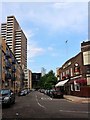
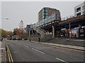
2
View up Limeharbour from Crossharbour DLR station
Image: © Christopher Hilton
Taken: 24 Mar 2016
0.02 miles
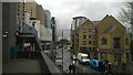
4
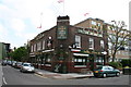
The George Inn
A pedestrian area between the corner of Glengall Grove and East Ferry Road and Crossharbour Station
Image: © David Smith
Taken: 15 Apr 2010
0.02 miles
5
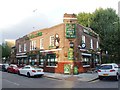
Cubitt Town: The 'George'
This pub is one of the few earlier buildings still standing around here. It is close to Crossharbour DLR station, and only just manages to edge into this gridsquare by a few feet.
Image: © Dr Neil Clifton
Taken: 14 Jun 2012
0.02 miles
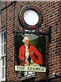
7
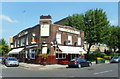
The George, Cubbitt Town
A remnant of the old docklands near Crossharbour DLR station. How often old pubs survive when mere houses have all been demolished. The George has lost a lot of its garish signboards since this previous image from 2014 Image but has also lost the date 1864 previously on the corner.
A close look above the George picture shows an old trademark sign of Watney, Coombe and Reid's Brewery and there is a Watney's lantern on the corner.
Image: © Des Blenkinsopp
Taken: 22 May 2018
0.02 miles
8
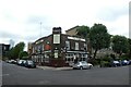
The George
Looking towards the pub on the corner of Glengall Grove.
Image: © DS Pugh
Taken: 2 Aug 2022
0.02 miles
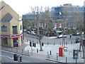
9
Crossharbour DLR and Millwall Docks railway station (site), London
Crossharbour station was opened by the Docklands Light Railway in 1987 on what is now the line from Docklands to Lewisham.
It is built on the site of the London & Blackwall Railway's Millwall Docks station which opened in 1871 as a single wooden platform, and closed in 1926. At that time, the line was a single track branch to North Greenwich, which is almost next to Island Gardens DLR station.
View south towards Mudshute and Lewisham.
Image: © Nigel Thompson
Taken: 16 Nov 2018
0.02 miles
10
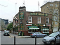
The George, E14
On the corner of the former East Ferry Road and Glengall Road, both now renamed Glengall Grove at this point.
Image: © Robin Webster
Taken: 5 Mar 2011
0.03 miles